
The trails of California’s Los Padres National Forest, etched into sandstone, winding through chaparral, and tracing coastal ridgelines, are inherently fragile, a characteristic amplified by a rapidly changing climate. Many of these routes were forged for purposes long past—cattle drives, mining exploration, early U.S. Forest Service fire patrols—while others were trodden by the Chumash people centuries before European colonization. Some sections cling precariously to steep slopes, their existence a constant battle against gravity, shedding soil and stone with every winter storm. Close inspection reveals remnants of old bench cuts and hand-built retaining walls, half-buried or consumed by the encroaching manzanita.
Now, as droughts deepen, floods intensify, and federal budgets dwindle, this inherent fragility has accelerated, leading to a rapid deterioration of these vital pathways. Trails marked as open on official maps are literally slipping off mountainsides, and drainages carved into sandstone are obliterated by single atmospheric river events. The result is a system increasingly shaped by erosion and abandonment rather than by the agencies tasked with its preservation.

Over the past decade, I have undertaken the restoration of hundreds of miles of Forest Service trails across the nation, from the Sierra Nevada to the eastern seaboard, often relying on outdated agency maps to locate paths that have vanished from both physical and digital landscapes. I have observed firsthand how a single missing trail line in a dataset can lead to significant discrepancies in federal budget requests, potentially altering appropriations by hundreds of thousands of dollars, as funding requests are directly tied to the total mileage recorded in an agency’s database. Similarly, an "open" trail symbol on the National Map, the comprehensive geospatial database maintained by the U.S. Geological Survey, can obscure years of damage from natural events. Corridors painstakingly cleared and maintained can disappear within a single season without continuous upkeep.
The U.S. Forest Service manages an immense network, boasting over 370,000 miles of roads—enough to circumnavigate the Earth nearly fifteen times—and approximately 160,000 miles of trails, representing 85% of all trails on federal lands. Despite this vast infrastructure, a 2013 Government Accountability Office report revealed that only about 25% of these trails met agency standards for maintenance and public safety. Alarmingly, just 37% of the national trail network receives any form of maintenance annually, leaving a substantial portion to fade from both the landscape and public awareness.
A stark internal report released by the Forest Service in December 2025 underscored the dire state of its trail system. A "Trail Program Status Report," shared with me and also obtained by The Washington Post, detailed Forest Service districts experiencing losses of up to 100% of their trail staff, the disappearance of hundreds of years of accumulated trail expertise, and widespread burnout and declining morale. The miles of trails maintained were 22% below average, and the number of miles meeting maintenance standards had dropped by 19%, marking the lowest level in fifteen years.

This decay is a direct consequence of decades of underfunding. According to a 2022 Congressional report, the agency estimates a $460 million backlog in trail maintenance alone, which is part of a larger $10.8 billion overall infrastructure deficit. Natural disasters such as wildfires, floods, and widespread beetle kill are erasing infrastructure at a pace far exceeding the capacity of available staff to rebuild. Across the Western United States, volunteers and small non-profit organizations have become the de facto caretakers of these national systems.
The maps accompanying this narrative aim to let the landscape and data illustrate the challenges facing trails. Each depicted location tells a version of the same story: due to climate change, natural disasters, wildfire, and a chronic lack of resources, our trails are vanishing at a rate that outpaces our ability to maintain public lands.
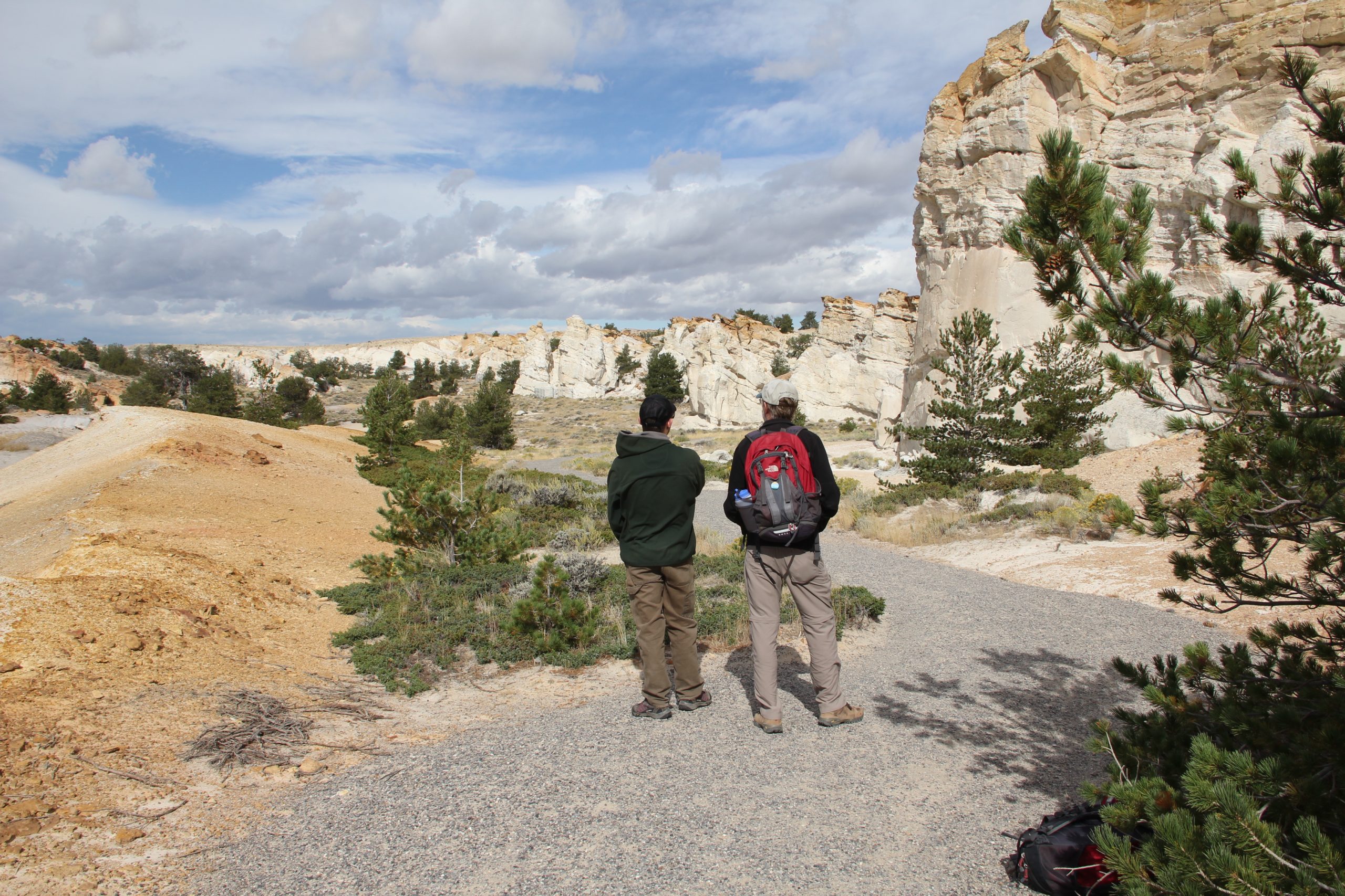
In late summer, I journeyed 30 minutes north of Santa Barbara into the Los Padres National Forest to verify a trail I had been studying, one that appeared clearly on the National Map and even on a paper map acquired at an outdoor retailer. What had once been a route marked by countless footsteps and hoofprints for hundreds, if not thousands, of years was now overgrown with dense chaparral and agave. My boots sank into soft dust as I followed the faintest suggestion of a ridgeline between manzanita bushes, the undergrowth closing in until it formed an impenetrable wall of branches. I pushed through thorny chamise and crawled under agave fronds, searching for a trail bed that, according to every official source, should have been beneath my hands and knees. However, there was nothing; only a corridor so neglected it had become indistinguishable from the surrounding hillside.

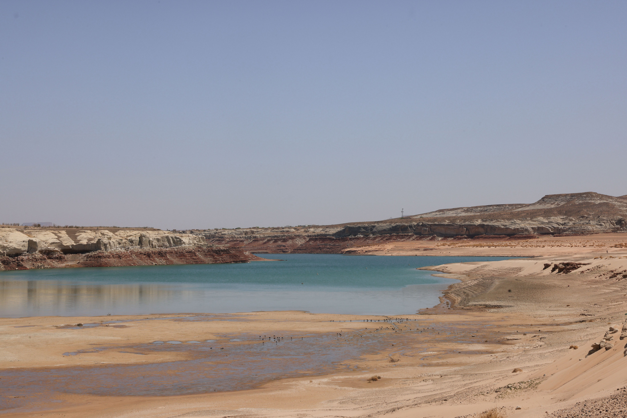
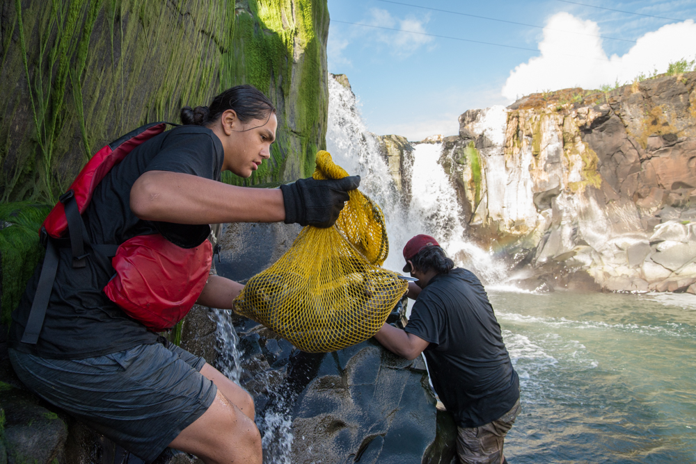
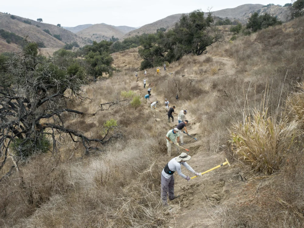
Here in the Los Padres National Forest, the Forest Service’s backlog in trail upkeep is starkly evident. Storms, wildfires, and heavy recreational use have transformed once-iconic routes into deep ruts, overgrown expanses of chaparral, and significant washouts. Of the hundreds of miles of trails within this national forest, volunteer crews now shoulder much of the maintenance burden, leaving countless miles unmaintained and their historical significance eroding.
The root causes of this deferred maintenance are multifaceted. Forest Service staffing reports from 2019 indicated a substantial contraction in the agency’s workforce over the preceding three decades, with a loss of approximately 20% of its staff. During the Trump administration, full-time staffing saw an additional 10% decline due to layoffs, though a recent Congressional appropriations bill spared the agency the most severe budget cuts previously proposed.
Recreational trail staff, once a robust contingent in the 1980s, has dwindled significantly with these reductions in force. Many districts now report having only one permanent recreation staff member, supplemented by fewer than three seasonal staff, tasked with overseeing hundreds of miles of trails. A July 2025 internal Forest Service report indicated that each of the agency’s nine regions was missing up to 80% of its trail and recreation workers.

The December 2025 follow-up report quoted numerous anonymous rangers expressing their deep concerns. One acting district ranger lamented, "My trail program is suffering the worst morale setbacks of all my district programs." Another forest recreation manager stated, "We lost 200 years of trail experience this year," while a district trail manager considered abandoning a multi-decade career, feeling that "24 years of trails and wilderness work… [is] rolling back to the bottom of the hill."
Volunteers and local stewardship groups have stepped in to fill critical gaps, demonstrating the profound value Americans place on access to public lands. In fiscal year 2023 alone, 71,660 volunteers contributed 2.6 million hours of service to the Forest Service, more than double the hours logged by agency employees. However, even this immense volunteer effort can only slow, not reverse, the decline of infrastructure that has accumulated over decades of mismanagement.
At the highest levels of government, a bipartisan acknowledgment of this systemic neglect is emerging. During his Senate confirmation hearing, Secretary of the Interior Doug Burgum emphasized the critical need to address the maintenance backlog, stating, "We just have to make sure not just the national parks, but across the whole department, we have to get the formulas right, because we are creating liabilities for future generations if we are not taking care of that deferred maintenance."

We place considerable trust in maps to accurately represent reality, as they delineate the contours of access and the extent of our shared natural heritage. When produced by government agencies, maps form the basis for laws guaranteeing access, guiding wildfire response, and shaping billions in recreation spending. Yet, for decades, even federal land managers have struggled to ascertain the true extent of legal access, with information often residing in handwritten easements in filing cabinets, decades-old agreements never digitized, and trails appearing on one map but absent from another.
This challenge prompted Congress to pass the MAPLand Act in 2022, an initiative aimed at Modernizing Access to Our Public Lands. This bipartisan bill directed the Forest Service, Bureau of Land Management, National Park Service, and Fish and Wildlife Service to locate, digitize, and publicly release all recorded access easements, trails, roads, and boundaries by 2027. The mandate, on paper, is straightforward: consolidate a century of scattered records into a single, authoritative digital basemap.
However, the reality is far more complex. The National Map officially lists approximately 300,000 miles of trails across public lands. OpenStreetMap, a public, volunteer-driven dataset that underpins most private navigation applications like Gaia GPS, Strava, Apple Maps, and AllTrails, adds hundreds of thousands more miles, capturing both sanctioned routes and informal paths derived from GPS data. Errors and omissions within federal datasets inevitably propagate into these popular apps. Conversely, the proliferation of unsanctioned, user-generated trails can complicate agency maintenance priorities and strain already limited resources.

The latest update on MAPLand implementation, presented at a webinar hosted by the nonprofit American Trails, indicated that while agencies have made progress in compiling existing digital layers, vast amounts of paper maps, access agreements, and legacy easements remain undigitized. The Forest Service has not met its goal of verifying 1% of its trails annually in the field since 2012.
While the effort has not completely stalled, and Secretary Burgum has directed limited funds toward access-related projects, including the digitization mandate, this political momentum has not resolved the fundamental issue: a pressing need for more personnel on the ground. The emerging basemap, while ambitious, remains incomplete and frequently inaccurate. The allocated funding is sufficient only to compile existing digital layers, not to dispatch staff into the field to research paper records and trail segments lost to the system decades ago. Consequently, the effort has gravitated towards producing a polished product—a clean digital layer based on readily available data—rather than an accurate representation derived from expensive, on-the-ground verification. Ultimately, the public may be presented with a map that appears authoritative while obscuring the very gaps the MAPLand Act intended to address.
The issues stemming from the Forest Service’s chronic underfunding manifest in diverse ways across the nation. In Oregon’s Oakridge-to-Ashland corridor, for instance, drought and beetle kill—exacerbated by climate change causing later autumn freezes—have resulted in vast expanses of standing dead trees. When winter windstorms sweep through, hundreds of thousands of these beetle-killed trunks fall like matchsticks. Crews return each spring to find trails buried beneath tangled blowdown, rendering once-cherished routes impassable for months, sometimes years. The sheer scale of this disturbance is so immense that even full trail crews, let alone volunteer groups, cannot keep pace. Furthermore, these downed trees leave forests increasingly vulnerable to wildfire.

Wildfire poses perhaps the greatest threat to Western forests. A 2023 report by the nonprofit Outdoor Alliance, "Wildfire and Outdoor Recreation in the West," found that over 5,000 miles of trails are impacted by wildfire alone each year. Colorado’s 2020 fire season was its worst on record, burning more than 665,000 acres and destroying over 200 miles of trails. With extreme fires now six times more common than in the 1990s, many trails simply vanish beneath fallen timber and unstable slopes.
A 2023 analysis from the Regional Economic Development Institute indicated that Colorado has averaged roughly 72 wildfires annually in the 2020s, a six-fold increase over the 1990s. Post-fire landscapes produce a secondary wave of destruction: deadfall that collapses across trails, unstable slopes prone to erosion during storms, and safety hazards that can keep entire trail networks closed for seasons. Millions of dollars are allocated through the federal Burned Area Emergency Response program towards roads, culverts, and utility protection, but trail reconstruction rarely receives comparable funding, leaving many routes functionally erased. Colorado’s 2020 Cameron Peak Fire, illustrated in the accompanying map, was one of nine significant wildfires within Roosevelt National Forest in the past decade, burning hundreds of miles of trails in a high-recreation-use district. Volunteers have worked to restore what trails they can, operating under the tacit acknowledgment that another fire is almost guaranteed to render their efforts Sisyphean.
Federal agencies like the Forest Service are often criticized for their perceived ineffectiveness in managing public lands, which can be used to justify further budget cuts. As Jamie Ervin, senior policy manager at the Outdoor Alliance, noted, "Agencies’ ability to respond to increasingly worsening climate disasters is hamstrung. Even with good intentions from local staff and volunteers, as well as funding from Congress in the case of disaster relief, a lessened Forest Service staff cannot organize to restore public land infrastructure for years after wildfire or hurricanes." In essence, climate change is outpacing not only the physical infrastructure on the ground but also the institutional infrastructure tasked with its care.

A compelling example of this phenomenon is currently unfolding in North Carolina. Following Hurricane Helene, which struck the Pisgah and Nantahala national forests, torrential rains triggered landslides that buried trails under tons of mud, fractured bedrock, and toppled timber. Entire trail segments vanished overnight. With roads, bridges, and community infrastructure devastated across western North Carolina, emergency funds and agency staff were diverted to prioritize travel corridors and utilities. Trails on public lands, already facing years of deferred maintenance, fell to the bottom of the priority list. Many remain closed not only due to the complexity of the repair work but also because dedicated crews are unavailable to reopen them, underscoring how rapidly a maintenance backlog can translate into a loss of public access. Climate events, in this manner, do more than reshape the landscape; they divert attention and resources away from areas already suffering from long-term neglect.
It is tempting to solely blame the government for the scale of these losses, but users of public lands must also acknowledge their own responsibilities. Too often, the culture of outdoor recreation and the industry that profits from it have encouraged individuals to act as passive beneficiaries rather than active stewards, enjoying access to public lands while contributing little to the labor or funding required for their maintenance. Americans spend an estimated $1 trillion annually on outdoor recreation. However, the specific federal accounts dedicated to funding the physical infrastructure supporting this industry—roads, conserved landscapes, and trails—are so limited that their totals are smaller than the annual operating budgets of some state park systems.
The ideal scenario involves federal agencies and the public collaborating to maintain trails as living infrastructure, guided by accurate, up-to-date mapping and supported by comprehensive Congressional funding. Outdoor recreationists could also play a more proactive role, perhaps through an excise tax or another dedicated funding stream that directly supports public lands, mirroring the decades-long contributions of hunters and anglers to federal conservation efforts through excise taxes and license fees.

Maps serve a purpose beyond charting terrain; they function as a social contract between the public and the agencies tasked with stewardship, a promise that what is depicted can be found, used, and defended. Each trail represents more than an opportunity for recreation; it signifies a chance to remain connected with the landscape and the nation’s history embedded within it. As the physical terrain changes at a pace that outstrips the ability of maps and management budgets to keep up, this contract frays. Individuals cannot advocate for landscapes they cannot access, experience, or no longer believe are intact.
We have inherited an expansive network of roads, trails, and easements carved through nearly every U.S. ecosystem. Some may naturally recede back into the wilderness, while others serve as vital lifelines for access and identity. The fundamental challenge lies in discerning which pathways to maintain, which to allow to fade, and which to actively fight to preserve or redraw. Every revision of a map carries a moral imperative.