
At 3:30 p.m. on Wednesday, December 10th, residents of Sumas, Washington, situated within the Nooksack River floodplain near the Canadian border, received stark notification of encroaching floodwaters. The city’s flood alarm blared a chilling warning, a sound that carried as far north as Abbotsford, British Columbia, signaling a dire situation. Most inhabitants heeded the urgent call, gathering their families, pets, and essential belongings before seeking refuge in designated flood shelters, hotels, or the homes of friends and neighbors.
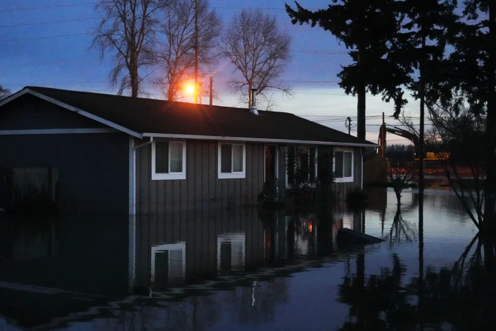
By the following morning, all routes in and out of Sumas lay submerged beneath multiple feet of frigid, silt-laden river water, a deluge that inflicted significant damage on hundreds of homes and businesses, leaving a pervasive layer of mud on nearly every surface. Dozens of individuals who had not evacuated were perilously stranded, requiring rescue from their rooftops by U.S. Coast Guard helicopters. As the waters finally began to recede on December 12th, the stark high-water mark was a ubiquitous reminder of the disaster, evidenced by the debris clinging to chain-link fences and the muddy stripes staining homes and vehicles throughout the inundated areas.

The Pacific Northwest was pummeled by two successive atmospheric rivers in early December, with some locations recording as much as 14 inches of rainfall within a 72-hour period at the storms’ zenith. The most severely affected regions were low-lying agricultural zones, while areas at higher elevations, including the foothills of the Cascade Range and urban centers like Seattle, Everett, and Bellingham, experienced comparatively less impact.
The arduous process of recovery has now commenced for the affected communities. On December 12th, in the town of Nooksack, located a short distance from Sumas, thick work gloves, tall rubber boots, and waterproof jackets became standard attire for volunteers assisting homeowners in the daunting task of salvaging what they could. Teams worked to remove waterlogged carpets and building materials to the curbside for collection, while others ventured into flooded crawlspaces, extracting sodden insulation and muddied vapor barriers. Additional volunteers from the Whatcom Long Term Recovery Group, an organization established in the wake of similarly catastrophic flooding in north Whatcom County in 2021, set up operations at the Nooksack Valley Church. They provided crucial assistance in both English and Spanish, guiding residents through the complexities of insurance claims and state aid applications, while also offering vital emotional support as individuals returned to their devastated neighborhoods and confronted the daunting question of what to do next. As of December 19th, nearly 800 families in Whatcom County had formally requested assistance from the recovery group.
Atmospheric rivers, characterized as narrow bands of concentrated water vapor originating from the warm waters of the Pacific Ocean, are a regular feature of West Coast weather patterns, bringing significant precipitation. However, this particular series of storms exhibited unusual breadth, unleashing rain as far south as central Oregon. Over 100,000 residents across Washington faced mandatory evacuation orders as coastal rivers draining the Cascade Range reached their peak flows on December 11th and 12th. In Skagit County, approximately sixty miles north of Seattle, the communities of Concrete and Hamilton bore the brunt of the flooding; Bridget Moran, a fisheries biologist working in Skagit County who was actively involved in home cleanup efforts, reported observing high-water marks exceeding six feet in some Hamilton residences. Further downstream, the Skagit River, flowing at a record-breaking 37.7 feet, was narrowly prevented from inundating downtown Mount Vernon due to the presence of a protective floodwall.

Not all communities were as fortunate. In the nearby city of Burlington, 55 homes and sections of the downtown core were submerged on December 12th, compelling the evacuation of the town’s nearly 10,000 residents. In south King County, floodwaters breached a levee on the Lower Green River near Pacific in the early morning hours of December 16th, prompting officials to order the evacuation of 2,100 residents from the affected area. Ultimately, the floodwaters impacted approximately 220 homes and around 800 individuals. In Snohomish County, south of Skagit, a 33-year-old man lost his life when his vehicle was swept away by floodwaters while attempting to drive on a closed road, marking the sole confirmed fatality attributed to the flooding thus far.
Communities situated at higher altitudes in the East Cascades, such as Naches, Leavenworth, and Methow, typically experience colder and drier climates compared to their counterparts west of the mountain range. However, the nature of this event, with a substantial portion of the precipitation falling as rain rather than snow, even in the uppermost reaches of the Cascades, led to catastrophic flooding, widespread power outages, and significant mudslides in these areas as well. In Stehekin, adjacent to the burn scar of the 2024 Pioneer Fire, residents and businesses suffered considerable damage from landslides and post-fire debris flows. These events were exacerbated in recently burned areas where scorched soils and vegetation are inherently more susceptible to destabilization. Further south along the Cascade crest, Stevens Pass sustained such severe damage that its closure is anticipated to last for several months, while multiple landslides obstructed eastbound Interstate 90, a critical transportation artery through the Cascades.
Washington was subsequently impacted by a third, albeit slightly colder, atmospheric river during the week of December 15th. This additional precipitation fell on watersheds already saturated from the preceding week’s rainfall, triggering further flooding, though to a lesser extent. The wind, however, proved to be a more destructive force than the water, with approximately 380,000 people across the state experiencing power outages.

The USDA Northwest Climate Hub points to the confluence of increasingly hazardous atmospheric rivers and the overarching phenomenon of climate change as significant contributing factors. A warmer atmosphere possesses a greater capacity to hold moisture, while a warming Pacific Ocean acts as a more substantial source of this moisture. Consequently, the duration and intensity of atmospheric river events are on an upward trend. Guillaume Mauger, Washington State Climatologist, explained that when these elements align, "we’d expect the storms to be more intense." Mauger further elaborated that the danger posed by this specific series of atmospheric rivers stemmed not only from their individual intensity but also from their rapid succession.
Mauger was careful to note that researchers are still in the process of gathering definitive data to precisely ascertain the impact of climate change on this particular storm sequence. However, he highlighted that the unseasonably warm temperatures and the shift towards rain over snow, even at higher elevations, were likely indicators of climate change’s influence. "Atmospheric rivers are warm in general," he stated. "But if this event had happened in 1950, the snowline wouldn’t have been quite so high. That’s the big effect: that it’s just less snow and more rain."
Communities across Washington are now navigating the recovery phase, with residents engaged in the arduous task of removing salvaged belongings and damaged materials from their homes and actively seeking financial assistance. Washington Governor Bob Ferguson has allocated $3.5 million in emergency funding to aid flood victims and has put forth a supplemental budget proposing $55 million designated for home repair and recovery efforts. President Donald Trump has approved Governor Ferguson’s request for federal disaster assistance, a move that will enable the Federal Emergency Management Agency (FEMA) to provide support to communities and local governments, though it does not directly unlock federal funding for individual victims.

Several factors are likely to complicate the recovery process in many of the affected areas, including a high proportion of renters, the prevalence of manufactured homes, and a notably low rate of flood insurance coverage, according to a report from the Urban Institute. In Whatcom, Skagit, and Snohomish counties, only about a quarter of homes located within the 100-year floodplain carry National Flood Insurance Program (NFIP) policies, which are federally administered plans designed for individuals who might otherwise struggle to obtain insurance due to their geographical vulnerability.
Shortly after the floodwaters receded on December 12th, I joined another volunteer in Nooksack to help a family remove ornaments and lights from their Christmas tree. The tree’s lower branches were coated in mud, and the floor around it was thick with silt. Elsewhere in the home, other volunteers worked diligently, carrying out waterlogged couches and children’s toys still dripping with river water. Later, standing in the driveway, I observed volunteers methodically carrying sodden items from every home on the block – a scene that would be replicated in thousands of residences across the state in the weeks and months to come. The sheer scale of the devastation was overwhelming, yet there was little time for contemplation. The task at hand demanded immediate attention: the removal of trim, the ripping out of flooring, the completion of essential paperwork, the rebuilding of lives, and, eventually, the renewal of communities.