Rocky Gerung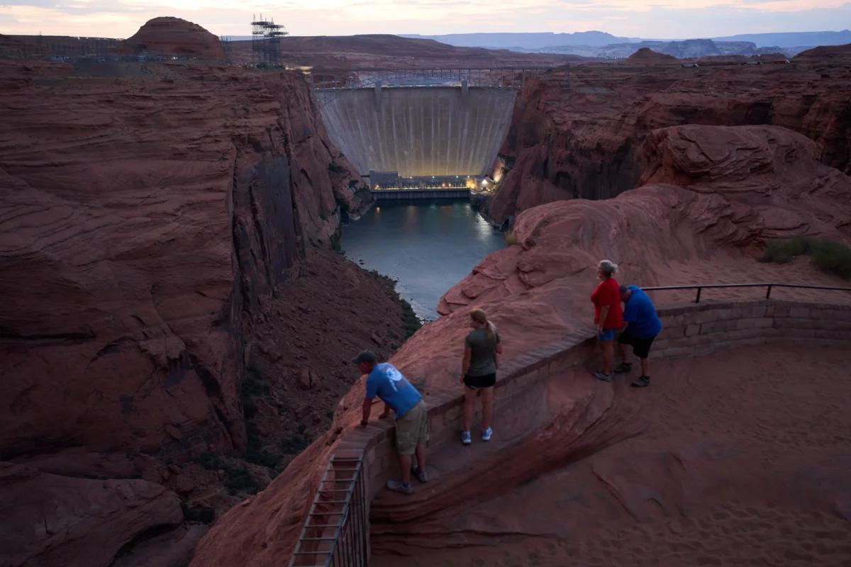
On August 29, monsoon storms unleashed torrential rains over northern Arizona, particularly battering the North Rim of the Grand Canyon. These storms triggered flash floods that surged with alarming momentum through the burn scar left by the 2025 Dragon Bravo Fire. Carrying a destructive payload of charred trees, massive boulders, and loose sediment, the torrents carved a path down Bright Angel Creek, relentlessly seeking the fastest route to the Colorado River below. The devastating floodwaters obliterated bridges, damaged structures, and tragically claimed at least two lives, while simultaneously reshaping the river’s course by eliminating beaches and forging new, treacherous rapids.
This summer, and indeed for the foreseeable future, the iconic Grand Canyon is undergoing profound transformations. Beyond the escalating severity of seasonal floods, a warming global climate is increasingly leading to critically low water levels in the canyon. The Glen Canyon Dam, situated upstream of the Grand Canyon, is consistently releasing water at its lowest volumes in decades, with projections indicating even further declines in the Colorado River’s flow. These shifts are already exerting significant pressure on recreational activities, the river’s delicate ecological balance, and the ancestral lands of local Indigenous tribes.
The Colorado River, arguably the most majestic and heavily managed waterway in the United States, flows through the Grand Canyon, its course effectively bookended by two colossal dams. These dams impound the largest reservoirs in the U.S., Lake Powell and Lake Mead, which collectively supply water to an estimated 40 million people across the Southwestern United States. However, these vital water sources have been in a state of steady decline for decades, a consequence of diminished snowfall and rising temperatures directly linked to climate change.
The current water levels in these reservoirs have shrunk to a point not seen since the 1950s, a period when only Lake Mead existed and was merely half full, according to Jack Schmidt, director of Utah State University’s Center for Colorado River Studies. In July of this year, inflows into the Colorado River system registered a mere 12% of their historical average. A Bureau of Reclamation study released in June further underscores the severity of the situation, projecting that Lake Powell could drop below the elevation required for hydropower generation by January 2027. This scenario poses not only a threat to energy production but also raises concerns about the structural integrity of the Glen Canyon Dam itself.

In response to these dire projections, the Bureau of Reclamation has initiated significant reductions in water releases from Lake Powell. Monthly releases have been curtailed from approximately 482,000 acre-feet to a projected 401,000 acre-feet by October. While these shrinking water levels will undoubtedly impact the entire river basin and beyond, the Grand Canyon is expected to bear the brunt of these changes earliest and most acutely.
"The Grand Canyon experienced low flows naturally prior to the dam," explained Jen Pelz, water advocacy director for the Grand Canyon Trust. "However, we have so significantly altered the system over the past 60 years through dam operations that simply reducing water levels won’t return us to natural conditions." The once-predictable pattern of high spring flows followed by low, warm summer flows is unlikely to re-emerge.
The profound shifts occurring within the canyon are perhaps most vividly understood by the 11 Indigenous tribes who have considered this region their ancestral home for millennia. "Tribal relationships extend back a millennium longer than any scientist has been studying the Grand Canyon," noted Kurt Dongoske, the Zuni tribal historic preservation officer and principal investigator for the Zuni Cultural Resource Enterprise. He elaborated that the Zuni people believe the Grand Canyon is the very place of their emergence into this world, highlighting a direct spiritual, cultural, and geographic connection between the canyon and the Pueblo of Zuni, where the Zuni River flows into the Colorado. Dongoske, who has participated in numerous Bureau of Reclamation meetings over decades, stated that the tribe’s perspective on the value of consistent ecosystem management has historically been overlooked. He anticipates that as water levels continue to drop, the agency will pay even less attention to the Zuni’s insights on ecosystem connectivity.
The impact of altered river flows is evident even at the most granular level, visible in the very sand that shapes the canyon. The Glen Canyon Dam now intercepts over 90% of the sediment that historically flowed through the Grand Canyon. Pelz pointed out that this lack of sediment transport is a critical consequence of reduced flows, as sediment forms the ecological and structural foundation of the canyon. It builds the sandbars essential for fish habitat and the beaches used by rafters. Without this vital sediment, vegetation struggles to establish itself, destabilizing riverbanks and diminishing forage and habitat for the wildlife and insects that are crucial components of the canyon’s food web.
Furthermore, sediment plays a protective role for invaluable cultural resources, including ancient Indigenous masonry dwellings, seasonal campsites, and rock art such as petroglyphs and pictographs. A 2023 U.S. Geological Survey report highlighted that windblown sand dunes historically provided a natural shield against water-based erosion around the Grand Canyon’s sensitive archaeological sites. With declining sediment levels, nearly 400 of these significant sites are now at increased risk.

Consistently low flows, starved of sediment, contribute to the gradual erosion of the canyon, with sand being carried downstream into Lake Mead rather than remaining within the canyon’s ecosystem. To counteract this, the Bureau of Reclamation has, since the late 1990s, typically conducted an annual "high flow experiment" in the spring or fall. This controlled release of a large pulse of water was designed to transport sediment into the canyon from upstream. However, this crucial experiment was neglected in 2025, and in 2026, despite sufficient sediment availability, the agency opted not to conduct it, deeming it politically unfeasible. "If we lose these high flows, we lose all the sediment in the canyon," Pelz emphasized, describing it as "one of the most significant impacts to the Grand Canyon."
As reservoir levels drop and less water is released through the canyon, the water temperature also changes. This is because the water is now being drawn from the sun-warmed upper layers of Lake Powell. While historically ranging between 45 and 50 degrees Fahrenheit, these temperatures are now approaching 60 degrees as the lake level recedes. Schmidt explained that this warming trend promotes algae blooms in the clear, warm water near the dam, a phenomenon that does not occur when the water is rich with sediment.
These elevated temperatures pose a significant threat to the prized blue-ribbon trout fishery located immediately below the dam, as these fish cannot tolerate the warmer conditions. This has substantial local economic repercussions, as recreation in the area represents a billion-dollar industry supporting thousands of jobs, from guiding and hospitality to public works. The warm upper layer of water also harbors another menace: smallmouth bass. These non-native fish thrive in warmer waters and are drawn through the dam’s turbines as water levels decrease, impacting the ecosystem. This is particularly detrimental to threatened native fish like the humpback chub, as smallmouth bass prey on their young.
Approximately 85% of the humpback chub population in the United States resides within the Grand Canyon. A decades-long recovery program successfully brought them back from endangered status in 2021, and a dedicated nursery now exists at the confluence of the Little Colorado River. However, this recovery effort is now under threat as smallmouth bass migrate through the river. "It’s an ecological, biological issue and a cultural one," Pelz stated. "Fish have been there with the tribes for time immemorial. When I think about the Grand Canyon without native fish, it fundamentally changes what it is." Compounding the issue, revenue generated from hydropower at Glen Canyon Dam directly supports the native fish recovery program, meaning reduced power generation leads to diminished funding for these critical conservation efforts.
In previous years, when river temperatures exceeded 60 degrees Fahrenheit for three consecutive days, the Bureau of Reclamation would implement "cool mix flows," releasing colder water from deeper within the lake. This measure was intended to deter smallmouth bass and algae, thereby balancing the ecosystem. However, with current low water levels, the agency has significantly less flexibility to adjust water releases to reflect the canyon’s natural variability, even when scientific consensus and established policies advocate for such actions. The Grand Canyon Trust is actively monitoring a U.S. Geological Survey gauge at mile 15 of the Colorado River to track temperature trends. As of September 10, the water temperature at this location was 69.4 degrees Fahrenheit, having continuously exceeded the threshold for triggering a cool-mix flow release for 87 consecutive days since late June.

Dongoske, who has served as a representative to the Glen Canyon Dam Adaptive Management Program since 1991, highlighted another long-neglected aspect of river management: Indigenous perspectives. The Zuni not only consider native fish as kin but believe that all fish possess inherent value and that the non-native species are not at fault for their presence in the canyon. "All life-forms deserve respect and their lives should be cherished, which is completely antithetical to how Reclamation treats non-natives," he asserted. "Historically, they have not given Indigenous epistemologies equal consideration with Western science knowledge."
Recreation within the Grand Canyon is inextricably linked to river flows and the health of the ecosystem, a fact increasingly apparent as river levels decline, according to Ben Reeder, a seasoned guide for Colorado River and Trail Expeditions. Approximately 20,000 people embark on commercial river trips through the canyon annually, as it offers the sole opportunity to experience the full grandeur of the Grand Canyon. These expeditions range from short, three-day motorboat excursions to extended, 18-day oar-powered raft journeys.
Reeder, who operates 36-foot motorboats through the canyon, described how diminishing river levels make navigating challenging rapids like Hance and Horn Creek increasingly difficult. "Running low water, especially in a big boat, is what separates decent boatmen from really good boatmen," Reeder stated. "It’s definitely more nerve-wracking." Guides have been compelled to adapt their routes, timing, and scouting strategies, with some companies already transitioning to smaller vessels to navigate the shrinking channels. While no accidents have occurred thus far, boats are increasingly getting grounded in the rapids. Reeder himself has modified his gear, now carrying a slingshot to help deploy a rope to shore if his boat becomes stuck. "It’s not just about river running, but what happens when things go wrong," he added.
"The Grand Canyon is a living, breathing thing. When you spend a lot of time down there, you start to understand it," Reeder shared, also serving as the Grand Canyon River Guides representative to the Bureau of Reclamation’s Technical Workgroup. He noted that guides are supporting each other as they collectively grapple with these changes, but expressed deep concern for the future of the industry. Trip bookings have reportedly decreased by approximately 25% following a post-COVID surge. Reeder fears that as the river continues to drop, it may eventually become impassable for larger boats, effectively ending the motorized sector of the industry. "The history of Grand Canyon boatmen has always been one of resiliency," he remarked. "I’m confident we’ll find solutions, but I’m not confident that I’ll necessarily be able to guide and run boats there the way I am now for the long term. We will have to adapt."
Current releases from Lake Powell fluctuate between 6,000 and 9,200 cubic feet per second, a stark contrast to the typical average summer flows of 13,000 cfs, according to Jennifer M. Erickson from the Department of the Interior Public Affairs. These critically low flows preclude options such as cool mix flows or high-flow experiments, the latter requiring releases of 31,500 to 45,000 cfs for one to four days. Low flows also eliminate the possibility of steady-state releases known as "bug flows," which Pelz of the Grand Canyon Trust explained aim to minimize fluctuations to allow insects to hatch, thereby supporting the food web, including bird populations downstream.

Dongoske emphasized the importance of considering the cascading effects beyond the immediate river corridor. "Whatever happens in the Grand Canyon will have impacts on the community of Zuni," he stated. "There’s a continuous spiritual connection." On a broader scale, Pelz observed that low water levels foster a pervasive sense of scarcity, inhibiting creativity and adaptability. The recent destructive flash flood also raises critical questions. "We really need to rethink how we’re going to manage the river or how the infrastructure is going to work," she concluded.