

A century ago, in the arid landscape of the American West, a pivotal agreement was forged to govern the lifeblood of the region: the Colorado River. The Colorado River Compact of 1922, intended to equitably divide the river’s waters among seven states, has become a focal point of intense debate as the river and its vital reservoirs plummet to critically low levels. The core of the modern dilemma revolves around a question that was once dismissed with a regional quip: how much of the Colorado River’s diminishing flow should be permitted to reach California, Arizona, and Nevada?
The origins of this tension can be traced back to the unique legal framework governing water use in the West. The doctrine of prior appropriation, often summarized as "first in time, first in right," grants senior water rights holders precedence over junior users. As California, a rapidly developing state with significant agricultural and urban demands, began to assert its senior water rights along the Colorado River in the early 20th century, less populous states like Colorado, Wyoming, and Utah watched with growing concern as their own access to the river’s bounty diminished. This perceived imbalance fueled a sense of animosity and envy, a sentiment that has only intensified as the river’s flow has become increasingly precarious.
To address these upstream-downstream conflicts and secure support for ambitious water infrastructure projects in the Lower Basin, the seven Colorado River Basin states convened to draft the 1922 Compact. This agreement carved the basin into two distinct entities: the Upper Basin, comprising Colorado, Wyoming, Utah, and New Mexico, and the Lower Basin, consisting of Arizona, California, and Nevada. The dividing line was established at Lees Ferry, Arizona. The compact stipulated that each basin would receive an annual allocation of 7.5 million acre-feet of water, a division that, at the time, was believed to be based on a generous estimation of the river’s average annual flow.
Crucially, the 30 tribal nations residing within the Colorado River watershed, who historically held the most senior water rights, were deliberately excluded from these negotiations. This exclusion represented a significant affront to tribal sovereignty and laid the groundwork for future conflicts as tribes later sought to quantify and exercise their water rights, which are integrated within the respective basin and state allocations. The ongoing discussions about necessary water cuts are complicated by how these reductions will impact individual users, including tribes, with those possessing pre-compact "present perfected rights" potentially being shielded from mandatory reductions.
For decades, the compact’s framework, despite its imperfections, largely functioned. The Upper Basin states consistently used less water than their allotted 7.5 million acre-feet, often around 4 million acre-feet annually. Conversely, the Lower Basin, particularly California, frequently exceeded its share, consuming as much as 11 million acre-feet in some years. This imbalance was manageable as long as the river could sustain the demand. However, the last 26 years have seen a dramatic shift.

The advent of the 21st century ushered in an era of prolonged drought and rising temperatures, profoundly impacting the Colorado River’s hydrology. Diminished snowpack in the headwaters has led to a significant reduction in the river’s natural flow. Since 2000, the average annual natural flow at Lees Ferry has hovered around 12 million acre-feet, a stark contrast to the earlier assumptions upon which the compact was built. In some critically dry years, like 2002, the flow dropped below 6 million acre-feet, barely half of what the Lower Basin alone consumed at the time.
This stark reality clashes directly with the compact’s provisions, particularly the "non-depletion clause." This clause mandates that the Upper Basin "will not cause the flow of the river at Lee Ferry to be depleted below an aggregate of 75,000,000 acre feet for any period of ten consecutive years." While interpretations vary, this provision appears to compel Upper Basin states to allow water to flow downstream to California, even if it means they face water shortages themselves.
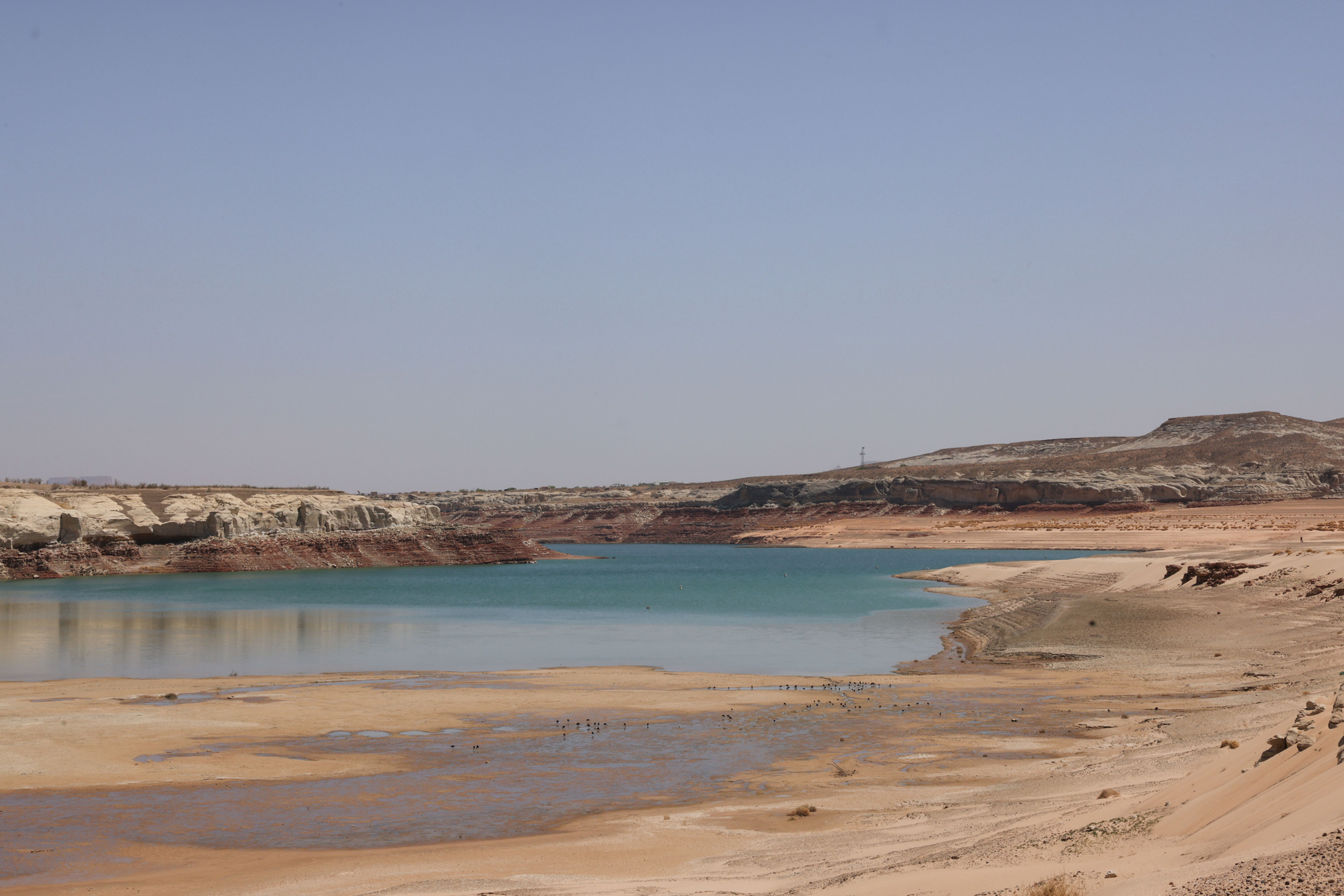
The construction of Glen Canyon Dam and the creation of Lake Powell were envisioned as a crucial buffer for the Upper Basin, serving as a vast reservoir to store water during wet years for use during dry periods. However, in recent decades, withdrawals from Lake Powell have consistently outpaced inflows. The reservoir now stands at approximately one-third of its full capacity, and its water level is precariously close to reaching the minimum power pool. This critical threshold is the point at which water can no longer flow through the dam’s hydroelectric turbines, halting power generation for millions of people across the Southwest.

If Lake Powell reaches its minimum power pool, a scenario federal forecasters warned could occur as early as the fall of the current year, the dam’s operational capacity would be severely compromised. Releases would be forced through lower outlets not designed for sustained high-volume use, potentially damaging the dam itself. Bureau of Reclamation engineers have strongly cautioned against this, effectively making the minimum power pool the de facto dead pool, beyond which operations become extremely hazardous.
Continuing climate trends suggest that avoiding this critical juncture requires either a substantial increase in water flowing into Lake Powell by curtailing Upper Basin water use and draining upstream reservoirs, or a significant reduction in releases from Glen Canyon Dam. The latter would impose severe cuts on the Lower Basin and impact the Colorado River through the Grand Canyon, threatening its delicate ecosystem and endangered native fish.
In response to the escalating crisis, the U.S. Department of the Interior in 2022 urged the seven states to collaboratively develop a plan to reduce overall consumptive use by 2 million to 4 million acre-feet annually, aligning demand with the river’s shrinking supply. To date, however, consensus remains elusive. The Lower Basin states, having already absorbed some cuts and facing the prospect of more, have indicated a willingness to accept further reductions, but only if the Upper Basin commits to mandatory and verifiable cuts of its own. Meanwhile, the Lower Basin seeks to preserve some form of the non-depletion clause.

Upper Basin negotiators contend that they have not yet reached their full water allocation and use significantly less water than the Lower Basin. They question the fairness of being compelled to reduce their usage further, especially given that water users in the Upper Basin, particularly those with junior rights, already face drastic shortages during dry years due to a lack of substantial water storage infrastructure. For instance, in 2021, many farms in southwestern Colorado saw their water deliveries cut off as early as June, leading to a lost growing season, while the Ute Mountain Ute Tribe received only about 10% of its allocated water.
Furthermore, reducing water consumption is logistically more straightforward in the Lower Basin, where water is delivered through a few large-scale diversions, such as the Central Arizona Project canal serving Phoenix and Tucson, the All-American Canal supplying the Imperial Irrigation District (responsible for the largest single water diversion on the river for its vast agricultural lands), and the Colorado River Aqueduct serving Southern California. In contrast, the Upper Basin draws water from the river and its tributaries through hundreds of smaller, more dispersed diversions. Achieving significant cuts would necessitate the curtailment of thousands of irrigation ditches serving numerous small water users, a complex undertaking with uncertain legal authority.
As an alternative, Upper Basin negotiators have proposed a "supply-driven" plan. This approach would base releases from Lake Powell on the real-time water levels in the river and reservoir, thereby respecting the spirit, if not the exact figures, of the Colorado River Compact. While Lower Basin negotiators have expressed some interest, details such as the precise percentage of flows to be released and whether a non-depletion minimum-flow requirement would persist remain points of contention.

Ultimately, the immutable forces of climate and hydrology may dictate the outcome of these negotiations. As Lake Powell’s levels continue to decline, the Bureau of Reclamation is likely to release water from upstream reservoirs like Flaming Gorge, Blue Mesa, and Navajo to temporarily bolster its levels. However, once the reservoir reaches its minimum power pool, dam operators will face a stark choice: release water through the river outlets, risking operational failure, or switch Glen Canyon Dam to a "run-of-the-river" operation. This latter scenario would equalize releases with inflows minus evaporation and seepage, leading to a drastic drop in Lake Mead’s levels. Such a development would force calamitous cuts on the Lower Basin, likely impacting the Central Arizona Project, one of the basin’s most junior water rights holders, jeopardizing the water supply for cities and farms that depend on it.
If these diminished releases were to continue for an extended period, the Upper Basin could find itself in violation of the non-depletion clause, potentially triggering litigation from downstream users and plunging the entire watershed back into the volatile and contentious era preceding the compact.
The initial sentiment that water flowing downstream to California was somehow lost or wasted has evolved into a more nuanced understanding of the interconnectedness of the Colorado River system. Every drop that flows downstream contributes to the river’s overall health, benefiting ecosystems and recreational users alike. The most significant flaw of the Colorado River Compact may not have been its optimistic water estimates, but its adversarial approach, pitting states, tribes, and users against one another rather than fostering a collaborative framework for the entire watershed’s benefit. As the climate continues its inexorable warming and drying trend, the diminishing water supply will render the compact increasingly obsolete. The time may be approaching to reconsider not only the compact’s terms but also the foundational principles of prior appropriation on the Colorado River, potentially starting anew to build a more sustainable and equitable water future.