Rocky Gerung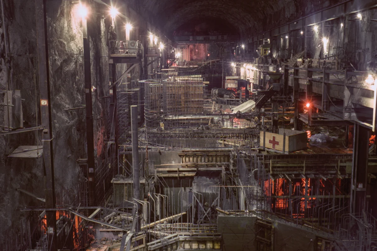
When construction began in 1961, California’s State Water Project (SWP) stood as one of the most ambitious water infrastructure undertakings in United States history, a monumental feat of engineering designed to quench the thirst of a rapidly growing, arid state. This vast network, spanning over 700 miles from the snow-fed Feather River watershed in Northern California to the arid expanses of Southern California, culminating at Lake Perris, remains a testament to mid-20th-century technological prowess and a symbol of California’s audacious belief in its ability to reshape the natural landscape. The California Department of Water Resources (DWR) has meticulously preserved a comprehensive public photo archive documenting the project’s construction, a visual chronicle that not only highlights the technical achievements but also captures a palpable sense of utopian optimism. These images, largely taken between 1962 and 1968, reflect a post-World War II era of confidence, where grand infrastructure projects were seen as the ultimate solutions to nature’s perceived shortcomings, particularly the persistent challenge of water scarcity in the American West.

The Edward Hyatt Powerplant, nestled near the imposing Oroville Dam in Butte County, exemplifies this spirit. Completed in 1967, this facility was designed to maximize power production through a sophisticated pumped-storage operation. During periods of surplus energy, water is pumped from Lake Oroville back into the reservoir, effectively storing it for use during peak demand hours when it is released to generate electricity. This innovative approach not only provided a vital source of power but also underscored the project’s multifaceted approach to resource management. Similarly, the Dos Amigos Pumping Plant, a crucial component of the California Aqueduct-San Luis Canal in Merced County, completed in 1966, was engineered to lift water over 100 feet, enabling its continued journey south. The construction images from this era, such as workers assembling rebar for discharge lines, depict a society united by the vision of progress and the tangible manifestation of human ingenuity.

The Oroville Dam Diversion Tunnel No. 1, a massive 35-foot diameter bore, further illustrates the scale of this endeavor. Initially built to reroute the Feather River during the dam’s construction, these tunnels were plugged upon completion in 1967 but later repurposed to discharge water from the Edward Hyatt Powerplant, showcasing the long-term adaptability of the project’s design. The visual narrative of the SWP’s construction is one of immense human effort and technological mastery, with photographs capturing workers painting primer coats on surge tanks atop hills overlooking pumping plants and dams, as seen at the South Bay Aqueduct in Alameda County in 1965. These images served a dual purpose: documenting engineering progress and projecting an image of state competence and forward-thinking vision.

Beyond their technical documentation, these photographs carry significant political and cultural weight. As anthropologist Brian Larkin noted, the aesthetic dimension of infrastructure often takes precedence, serving to "rearrange the hierarchy of its functions so that the aesthetic dimension of infrastructure (rather than its technical one) is dominant." The sheer visual grandeur of these projects was intended to inspire public confidence and support, presenting the state as a heroic entity capable of overcoming environmental challenges. This mid-century sentiment, where citizens readily rallied behind large public works, contrasts sharply with contemporary attitudes, where the dismantling of aging infrastructure, such as the recent removal of the Klamath dams, is often met with greater public enthusiasm than its construction.

The intricate network of waterways that feed the SWP originates from the confluence of the Sacramento and San Joaquin rivers in the Sacramento-San Joaquin Delta. This vital region, characterized by over a thousand miles of levees, numerous reclaimed islands, and a sprawling web of waterways, serves as the central hub for both the federal Central Valley Project (CVP) and the southern portion of the State Water Project. The California Aqueduct, a concrete leviathan stretching across the state, is the physical embodiment of the vision articulated by Erwin Cooper, a former DWR information officer, who aptly dubbed the system an "Aqueduct Empire." This empire was built on the premise that large-scale water management could solve the fundamental problem of supplying a burgeoning population in an inherently arid region.

The political philosophy underpinning these massive projects was one of control and transformation. The construction of the SWP began shortly before the publication of Rachel Carson’s seminal work, Silent Spring, which ignited the modern environmental movement. While the project was conceived during a period of burgeoning environmental awareness, its optimistic mid-century outlook has since encountered the harsh realities of 21st-century environmental challenges. Climate change, coupled with the overexploitation of water resources, has inflicted significant damage on the Western landscape, casting a long shadow over the once-unquestioned promise of engineering solutions. The infrastructure that once symbolized hope and progress is now often viewed as a historical relic, requiring constant and costly repairs. The dramatic failure of the Oroville Dam’s spillway in 2017, which necessitated the evacuation of nearly 200,000 people, serves as a stark reminder of the vulnerabilities inherent in such aging, colossal structures.

The Department of Water Resources’ Photography Unit continues its vital work today, with six photographers documenting the state’s water infrastructure and Bill Kelley III, the unit’s archivist, meticulously scanning and preserving an immense collection of negatives and slides. Housed in a windowless room at the department’s Sacramento headquarters, this unit faces the monumental task of digitizing an estimated 250,000 historical images, a project that will likely extend far beyond Kelley’s tenure. Initially conceived as a resource for engineering research, the commitment to this long-term photographic documentation underscores the DWR’s understanding of photography’s political power. These images serve not only as a visual record of the state’s water management history but also as a powerful tool to justify the department’s ongoing initiatives and potential expansion.

The sheer volume of photographic material amassed over seven decades speaks volumes about the role of imagery in shaping public perception and policy. The DWR’s archive visually chronicles California’s persistent quest for a utopian ideal: a state where water flows abundantly through rivers and aqueducts, sustaining its agricultural heartland, its sprawling cities, and its dynamic industries, perpetually defying the region’s inherent aridity and securing its promised future. This vision, however, is increasingly challenged by the fundamental geographical reality of the Western United States – its position west of the 100th meridian, a climatic divide that has historically defined the boundary between humid and arid lands. The ambition of re-engineering the environment on such a grand scale is undeniable, but the West’s aridity remains an immutable force, posing an enduring threat to California’s water utopia, regardless of the sophistication of its infrastructure or the aesthetic appeal of its documentation. The construction of the California Aqueduct, a project born of mid-century optimism and engineering ambition, now stands as a complex legacy, prompting reflection on the long-term sustainability and evolving environmental context of large-scale water management in the American West.