Rocky Georgio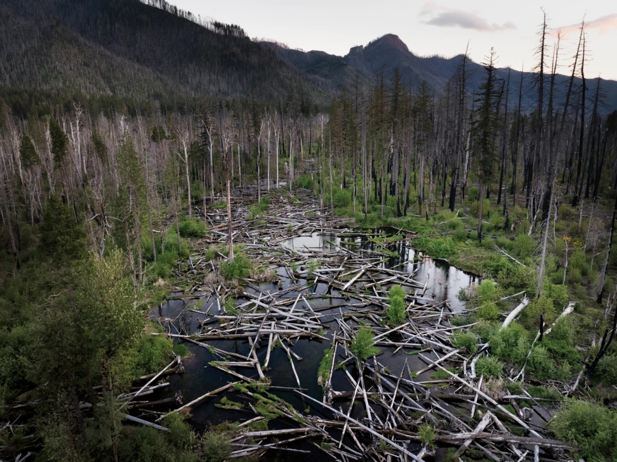
The story of Quartz Creek’s formation began approximately 12 million years ago when volcanic plateau crust uplifted and buckled, creating the nascent shape of the Western Cascades mountain range. Over eons, relentless forces of rain and ice sculpted this rocky foundation, carving deep canyons and transporting eroded sediment downstream to settle across gentler slopes. In these expansive depositional valleys, such as the area where Quartz Creek flows, water naturally spread, fostering a mosaic of wetlands interconnected by a network of branching channels. This dynamic aquatic environment was once a thriving habitat for Chinook salmon, bull trout, and Pacific lamprey, species that hatched and matured in the slow-moving waters. Many of these fish undertook epic migrations to the Pacific Ocean and returned years later, their journeys from the sea bringing vital marine nutrients that enriched the surrounding riparian forests of cottonwood, fir, and hemlock. The landscape was further shaped by frequent windstorms, wildfires, and landslides that toppled trees, strewing them across the valley floor. Beavers, natural engineers of the ecosystem, would then utilize this fallen wood to construct dams, creating ponds and altering water flow.
While this constant flux might appear chaotic, it was the very engine of the valley’s enduring stability. This dynamic process prevented any single channel from dominating, maintaining a rich tapestry of deep pools, turbulent confluences, sandy bars, gravel beds, fast currents, and slow side-channels. This diverse habitat supported an equally rich array of flora and fauna, which in turn sustained human populations. Indigenous tribes and bands, including the Kalapuya, Mollala, and Warm Springs, historically inhabited these areas year-round at lower elevations, migrating to these richer hunting and gathering grounds in the summer to fish, hunt, and collect huckleberries and hazelnuts.
The mid-19th century marked a profound shift with the arrival of Euro-American settlers. By 1860, the U.S. government had forcibly relocated the region’s Indigenous peoples to reservations – their descendants now belong to the Confederated Tribes of Grand Ronde, Confederated Tribes of Siletz Indians, and Confederated Tribes of Warm Springs – paving the way for widespread forest harvesting. Streams like Quartz Creek, with their swampy floodplains and unpredictable flows, presented significant obstacles to these new land management practices. Consequently, settlers embarked on extensive efforts to control the waterways, digging drainage ditches, constructing berms, and raising roadbeds. This intervention gradually consolidated the creek’s numerous channels into a more confined, ditch-like form. The valley itself was dramatically reshaped; the concentrated flow deepened the creek’s main channel, while the rest of the floodplain became progressively drier. With fewer downed trees reaching the water and accelerated currents flushing sediment downstream, the calm pockets essential for fish habitat dwindled. Consequently, Pacific lamprey populations declined, and Chinook salmon and bull trout vanished from the area altogether.
The transformation of Quartz Creek’s naturally untamed flow into something resembling an engineered channel undoubtedly required immense labor. Standing on the bridge that August morning, observing another group of humans engaged in intensive work, this realization struck home. Employing modern technologies such as excavators, LiDAR, and GPS mapping, these individuals were attempting to reverse the efforts of their predecessors, aiming to reconfigure the valley once again.
This ambitious undertaking represents the latest phase of a river restoration initiative launched a decade ago within the McKenzie River watershed. It employs an innovative approach known as Stage 0, which seeks to transform formerly canal-like channels back into dynamic wetland-stream complexes by regrading sections of the valley floor. This process is inherently bold, necessitating a significant disruption of the existing landscape. The long-term effects of this method are still under study, and the project’s scale is unprecedented. As geomorphologist Gordon Grant aptly described it, "It’s a full-on field experiment."
The McKenzie River is a cherished resource for boaters, anglers, and environmentalists alike, and the application of this highly invasive restoration technique has sparked considerable debate. However, others view it as a critical opportunity to mend some of the damage inflicted upon the watershed before it becomes irrevocably too late.

Historically, the McKenzie River was a vital stronghold for an estimated 110,000 Upper Willamette River chinook salmon, a species now listed as threatened. These salmon are ecologically and culturally integral to the Columbia River Basin. Today, the McKenzie’s wild chinook population represents less than 2% of its historic abundance, yet it stands as the largest remaining wild population and the best hope for the species’ recovery. Without significant intervention, some analyses predict the potential extinction of this population by 2050. "We know we don’t know everything," stated Elizabeth Goward, community engagement manager for the McKenzie River Trust. "But if we don’t act now, we could lose this species."
Brian Cluer, a fluvial geomorphologist, began his fascination with the land from the cockpit of an airplane as a teenager, observing the terrain surrounding his Idaho hometown. This aerial perspective likely shaped his later understanding of river systems. As a student, Cluer studied the foundational principles established by early geomorphologists like Luna Leopold, who theorized that undisturbed streams naturally formed single, meandering channels – an archetype that profoundly influenced both restoration goals and public perception, with most envisioning a pristine river as a winding ribbon of clear water.
In the 1990s, hydrologist David Rosgen popularized Natural Channel Design (NCD), a restoration method that utilized formulas based on these seminal studies and detailed site assessments to guide the reshaping of impaired streams into their perceived natural, stable forms. At that time, federal regulations allowed developers to offset environmental impacts by restoring habitats elsewhere, propelling river restoration into a multi-billion-dollar industry. NCD was widely adopted by private companies and public agencies. Although Rosgen’s designs allowed for some channel evolution, many practitioners reinforced banks with riprap and boulders, effectively locking the channels in place. Some of these projects proved disastrous when floodwaters overwhelmed the fixed structures. Overall, Cluer noted, many NCD projects failed to deliver on their ecological promises.
"When you think about rivers in that way, you always get a wiggly, single-thread channel," Cluer remarked, contrasting this with his decades of aerial observation. He had observed remote river valleys that lacked defined channels, appearing more like extensive wetlands. "That got my creative thoughts going," he admitted.
In 2008, a groundbreaking study published in Science validated Cluer’s observations. Researchers re-examined mid-Atlantic streams previously studied by early geomorphologists, revealing that these were not "natural" in the assumed sense. Instead, they had been significantly altered by mill dams constructed by Euro-American settlers starting in the late 1600s. The authors concluded that the single-channel archetype was an artifact of historical human manipulation.
Concurrently, researchers across the Western U.S. and beyond were delving deeper into historical accounts and employing advanced technologies like LiDAR to gain a more nuanced understanding of landscape histories. While specific circumstances varied, their conclusions converged: many precolonial streams likely resembled multi-threaded wetlands rather than simple winding ribbons. Synthesizing this burgeoning body of research with their practical experiences, Cluer and fellow fluvial geomorphologist Colin Thorne began developing an updated model of stream evolution. Their model departed from the single-channel paradigm, positing that the initial state of a valley floor was a wet, stream-laced expanse, a concept they termed Stage 0.
While Thorne and Cluer were formulating their theoretical framework, fish biologist Kate Meyer, then with the Forest Service, was tasked with enhancing fish habitat in the McKenzie watershed. She and her team focused on restoring Deer Creek, a tributary that, like Quartz Creek, had suffered decades of logging and "stream cleaning" – a misguided practice in the 1960s and 70s aimed at improving river health by removing logs and debris. This practice had virtually eliminated wood from the system, and berms confined the stream to a straightened, high-velocity channel, which Meyer described as "essentially a firehose."

Working with the McKenzie Watershed Council, Meyer’s team initially planned to restore the creek by adding wood, using logjams to slow water and trap sediment. "It was what everyone was doing at the time," she recalled. However, the results were consistently disappointing, with high-energy streams often washing out the added wood, and sediment accumulation taking decades even when logjams remained intact.
Meyer was aware of an alternative approach being explored in eastern Oregon. Instead of trying to improve existing channels, colleagues were focused on eliminating them altogether. This concept gained traction in 2002 when fisheries biologist Paul Powers visited an NCD restoration project in the Siuslaw National Forest that had been impacted by a landslide. While project leaders initially viewed the landslide as a catastrophe that had ruined their designed channel, Powers observed that the displaced earth had dispersed the stream across the valley floor, creating slower flows, expanding wetlands, and improving fish-rearing habitat. He began attempting to replicate this outcome at Whychus Creek in central Oregon, intentionally diverting flows out of the channel and onto the floodplain.
In 2014, Meyer attended a river restoration symposium where Cluer and Thorne presented their new research on Stage 0. "It was a total epiphany moment, to see the concepts we were working with as practitioners described from the theoretical perspective," she said. When Powers joined the Deer Creek team in 2016, he proposed implementing Stage 0. Meyer expressed excitement, but also apprehension. "I thought, ‘You mean we’re just going to bury the stream?’"
The team began on a smaller scale, dismantling levees and using the material to fill sections of the channel. The stream immediately began to spread across the floodplain, creating multiple slower-moving channels and deeper pools. In contrast, the unfilled reaches showed little immediate change. When Meyer and Powers invited Cluer and Thorne to visit their projects, the researchers were astonished to witness their theories being put into practice. "I thought, ‘Oh my goodness, these people are actually doing it,’" Thorne recounted.
Emboldened by the support of Thorne and Cluer and the observed improvements in Deer Creek – where Chinook salmon were found spawning for the first time since 1993 in 2017 – Meyer and her team were eager to undertake a larger project. In 2018, they initiated work on the South Fork tributary of the McKenzie, with plans to restore a 200-acre stretch to Stage 0 conditions. By this time, practitioners like Meyer and Powers had developed a practical methodology for implementation.
The initial step, and often the most contentious, involves identifying a suitable site. Stage 0 is most effective in low-gradient, historically depositional valleys where streams can naturally spread across their floodplains without impacting infrastructure. However, determining the acceptable gradient threshold remains a subject of debate, and understanding landscape histories is a continuously evolving process. Next, practitioners utilize historical clues, such as relic wetlands or stands of old-growth trees, to approximate the valley floor’s original shape before European settlement. Using LiDAR technology, they map the precise present-day topography, compare it to the target historical shape, and develop a detailed grading plan. Fish are carefully trapped and relocated downstream, and the river’s flow is temporarily diverted into a side channel. Then, heavy machinery, including bulldozers and excavators, reshapes portions of the valley floor, filling existing channels and removing levees. Logs and woody debris are strategically placed across the floodplain, some partially buried and others left to move naturally. This wood serves a dual purpose: creating habitat and slowing water flow, functions critical for the eventual regrowth of vegetation. Finally, the diversion is removed, allowing the stream to disperse across the valley floor and commence the intricate process of rebuilding the riverscape.
The construction of a Stage 0 project, while visually disruptive, is a necessary precursor to ecological restoration. When visiting Quartz Creek in August, the landscape presented a stark image of transformation. A muddy stream meandered alongside hundreds of acres of dusty soil, strewn with dead wood – massive logs, tangled branches, and piles of slash. "People say, ‘This isn’t Stage 0, it’s Ground Zero – it looks like you nuked the place,’" Thorne remarked. However, Lara Colley, a local resident and the floodplain restoration projects manager for the McKenzie Watershed Council, viewed the site with pride. Dressed in an orange vest and hard hat, she gestured toward a largely cleared staging area, exclaiming, "They’re all gone!" referring to the logs. Until recently, some 6,700 logs and pieces of wood had been stockpiled there; now, they were distributed across the floodplain. Colley, who had dressed as a log for Halloween, had sourced the wood from Forest Service and Bureau of Land Management lands where trees had been thinned for wildlife habitat or removed following recent wildfires. "I could’ve looked at a log and told you where it came from," she stated.

Since the Forest Service and the McKenzie Watershed Council began collaborating on Stage 0 projects in 2016, the Eugene Water and Electric Board (EWEB) and the McKenzie River Trust have joined the project’s leadership. This collaborative ecosystem, as Goward described it, has enabled the work to continue despite recent federal layoffs and budget cuts. Each partner brings distinct perspectives and resources, fostering a resilient approach to restoration.
For EWEB, a public utility responsible for supplying drinking water from the McKenzie River to 200,000 residents in the Eugene metropolitan area, stream restoration is a crucial component of protecting water quality. "Quartz Creek has always been our chocolate milk," said EWEB’s Water Resources Supervisor Susan Fricke, referring to the sediment that historically clouded the creek during high flows, taxing EWEB’s filtration systems. By allowing the flow to spread across the floodplain, sediment can settle out before reaching the mainstem, significantly reducing the costs and chemical treatments associated with its removal. "We consider the river part of our infrastructure," Fricke explained during the visit to Quartz Creek. "Preventing the problem is so much better than dealing with it later – we’re helping protect our future selves."
The natural resources department of the Confederated Tribes of Warm Springs has actively provided input on the project. "Stage 0 offers a holistic view of restoring river wetland corridors that reflects the Tribes’ goals for creating sustainable fisheries populations," tribal fisheries biologist Logan Bodiford stated. "Our hope is that this project will better enable tribal members to exercise their treaty rights and access culturally significant resources."
The design for Quartz Creek was led by Meyer, who transitioned from the Forest Service in 2025 to co-found a restoration consulting company. Franklin-Clarkson Timber Co., the private timber company owning much of the land surrounding the creek, facilitated access through a 50-year stewardship easement. The National Oceanic and Atmospheric Administration provided significant funding for the $9.5 million project with a $7.6 million grant, made possible by the Infrastructure Investment and Jobs Act. The actual heavy construction, including earthmoving and log placement, was executed by Haley Construction, a family-run company from Lebanon, Oregon, known for its extensive experience in logging and heavy civil projects.
With a tight window of less than three months of dry weather to complete the project and a complex array of elements – including a crew of over 20, 11,200 cubic yards of slash, acres of earth, a flowing river, and numerous logs – managing the construction site was a demanding endeavor. "It’s like directing an orchestra, getting everyone working together in a timely fashion," said Randy Haley, co-owner of Haley Construction. His daughter, Ashley Haley, project manager, added with a laugh, "And in harmony!" She described restoration projects as demanding but immensely rewarding, offering the satisfaction of contributing to community and wildlife well-being. Many on the Haley crew shared this sentiment; one man, having retired after 47 years with the company, continued to return each summer specifically to participate in these projects.
When Randy Haley’s parents founded the company in 1958, their primary focus was on timber operations, including road construction and log hauling. Over seven decades, the company’s evolution has mirrored shifting societal priorities. The Haleys have since been involved in building bridges, constructing and removing dams, and, for the past 35 years, undertaking an increasing number of river restoration projects. "You have to be able to adapt to changing needs, to reinvent yourself," Randy emphasized.
Today, Haley Construction leverages its deep logging expertise to help remediate some of the environmental impacts of that industry. "The knowledge of how to work with wood, in forests and around waterways, all that now lends itself to floodplain restoration," Ashley explained. Randy added, "But we can’t condemn the loggers. They were doing a job they believed was right, at the time."

Witnessing the Haley’s machinery reshaping a bare valley floor that had, until recently, been a vibrant riparian corridor, it was difficult not to feel a pang of unease. This sentiment was amplified by the surrounding mountainsides, cloaked in standing dead trees – a stark reminder of the devastating 2020 Holiday Farm Fire, which burned over 173,000 acres surrounding Quartz Creek.
The Holiday Farm Fire, unexpectedly, played a significant role in advancing the Stage 0 work in the watershed. It provided an abundant source of logs for the restoration efforts. Furthermore, the fire made the perceived disruption of heavy equipment operation more palatable to some observers. "It’s easier to bring heavy equipment into a scorched valley, harder to drive a bulldozer into a beautiful second-growth forest," Goward observed. Perhaps most significantly, the fire illuminated one of Stage 0 restoration’s most compelling co-benefits. The blaze swept through the 200-acre restoration site on the South Fork of the McKenzie, then the largest Stage 0 project ever undertaken. Preliminary observations suggest that while unrestored areas experienced uniform, severe burning, the restored region burned in patches, allowing wildlife to find refuge and facilitating a quicker forest recovery. In some sections of the restored reach, the expanded water surface acted as a firebreak. "We didn’t expect this to be part of fire resiliency," Fricke noted. "But it was."
During an afternoon visit to Quartz Creek, thunderheads had gathered, casting long shadows across the ravaged valley floor as the team departed the job site. Fricke pointed to a line in the dust: bobcat prints. The tracks led to the water’s edge before disappearing, hinting at the return of wildlife to the altered landscape.
While the physical construction of a Stage 0 project can be challenging to witness, the underlying concept offers a compelling vision of renewal. Faced with the extensive ecological disruptions of human activity, the idea of a fresh start is undeniably appealing. This approach, even down to its terminology ("Stage 0" or "valley reset"), seems to promise an opportunity to return to a pristine beginning, or even before the beginning, akin to wiping a slate clean and starting anew.
However, both proponents and critics caution against such simplistic framing. "We don’t expect to put everything back to the way it was before Lewis and Clark," Thorne stated. "What we’re doing is empowering nature – by which I mean birds, amphibians, trees, plants, bacteria, everything – to get to work on the riverscape again, to be able to make and remake it continuously." Advocates believe this will foster a greater diversity of habitats and biota, thereby enhancing the watershed’s resilience to future climate extremes. "Will it come out like it did before? Probably not," Thorne conceded. "It’s a different world now, a different river, a different catchment."
Critics argue that recreating historical Stage 0 landscapes is not only improbable but, in most locations, likely never accurately existed. David Rosgen, now 84 and still involved in NCD projects, believes the web-like stream networks characteristic of Stage 0’s initial conditions were confined to extremely low-gradient valleys and deltas. In such environments, he acknowledges, Stage 0 restoration can be effective. "But a good idea applied as a universal solution is a bad idea," he asserted. He contends that locations like Quartz Creek and the South Fork of the McKenzie possess gradients too steep to have historically sustained extensive wetland-stream complexes, and that these rivers would be most stable and ecologically beneficial as meandering channels.
Stage 0’s emphasis on allowing natural processes to shape streams stands in contrast to Rosgen’s method. However, Gordon Grant, a retired research hydrologist with a distinguished 40-year career at the Forest Service’s Pacific Northwest Research Station, observes a parallel surge of enthusiasm for both approaches. "There’s a particular bandwagon effect that seems to associate with restoration," he commented.

Grant dedicated his career to studying how streams in the Western Cascades respond to logging, dams, and climate change. "If there is any river system on Earth I have any claim to even modestly understand, it is the McKenzie," he stated. Upon learning of the Stage 0 work in the watershed, he began a thorough investigation. "I’ve never tried to restore a river, and have nothing but admiration for those who do," he said. "But I don’t necessarily worship at the same church as the restoration community."
A self-proclaimed "science geek," Grant describes the landscapes being created on the McKenzie as "novel geosystems." He elaborated, "There’s nothing in the history of these creeks that looks like that. I like experiments; it’s how we learn things, how we get better." However, he stressed that experiments warrant rigorous study before widespread implementation, citing past cautionary examples such as "stream cleaning" and flawed NCD projects. "So let’s stand back and ask: What potential risks are being set into motion here?"
Grant, author of the paper "When do logs move in rivers?", expressed particular concern regarding the potential impact of severe floods on the large wood incorporated into these projects. Mobilized logs can inflict significant damage on infrastructure—bridges, dams, docks, and embankments—and pose a threat to boaters and swimmers. While Stage 0 projects incorporate grate-like logjams designed to trap wood within the restored reach, these systems are not foolproof, especially in high-energy mountain stream environments like those found in the McKenzie watershed. "The potential for mischief has not been fully reckoned with," Grant warned.
During a visit to his office, Grant stood before a whiteboard, meticulously illustrating basic equations of fluvial dynamics to explain them to a journalist with limited physics background. He emphasized the immense power of floodwaters, capable of lifting and propelling enormous logs. He recalled observing the McKenzie River during the last major flood in 1996. "The stream you visit at low-flow, moderate-flow, even big winter flow, is nothing like what you see in an extreme flood," he stated. "And a 100-year flood means each year we have a 1 out of 100 chance it will happen. That’s a significant risk."
Conversely, inaction also carries inherent risks, including species extinction, exacerbated wildfire impacts, and diminished water quality. Grant pointed out that determining which risks are acceptable often depends on the perspectives of those involved in the decision-making process. He observed that in this particular project, "it’s mostly people trying to make the world better for fish."
Rebecca Flitcroft and Brooke Penaluna, research fish biologists with the Forest Service’s Pacific Northwest Research Station, highlighted a significant knowledge gap concerning the precise impact of Stage 0 on fish populations. While salmon are the primary driver of the Pacific Northwest’s restoration economy, Flitcroft noted, "The biggest gap in the literature on Stage 0 is actually around the question of: What does this do for fish?" Due to the inherent difficulty in directly monitoring fish, researchers often assess impacts by measuring changes in habitat. "The assumption is: if you build it, they will come," Flitcroft remarked.
Current research suggests that Stage 0 projects can indeed create the intended habitat. A study examining 17 sites across Oregon and Washington found that Stage 0 restoration led to an increase in low-velocity rearing habitat, broadened the wetted area of valley floors by several factors, and boosted the overall production of macroinvertebrates, a critical food source for salmonids.

These ecological shifts may benefit not only salmon but also Pacific lamprey, a native fish of profound cultural significance to Indigenous communities. Historically abundant in the Columbia River Basin, lamprey were a vital food source for many regional tribes, but their populations have experienced a dramatic decline. Lamprey share many habitat requirements with salmon and, like salmon, provide essential ecosystem services. Larval lamprey filter-feed in river sediments for up to a decade, purifying water and cleaning gravel beds in the process, while adults transport marine nutrients to freshwater creeks. Despite their ecological importance, lamprey have historically received limited attention from non-Native conservationists.
However, not all findings from Stage 0 studies have been unequivocally positive. Salmon require cold water, and researchers observed a tendency for temperatures to rise following restoration. Sediment composition shifted from coarse to finer particles, which, while beneficial for lamprey, can potentially clog salmon gills and fill the gravel beds necessary for spawning. Environmental DNA (eDNA) analysis revealed an increase in overall aquatic biodiversity, which includes both native and invasive species. "When you open up a channel, you open it up to everybody," Penaluna cautioned.
The most significant unresolved question pertains to the long-term outcomes. Although a Stage 0 project can be constructed within a matter of months, the true work of river restoration commences only after the heavy machinery departs and the water returns. Will these sites cool as shade trees mature? Will the sediment composition stabilize? Will the logjams remain in place?
Luke Whitman, who leads the Oregon Department of Fish and Wildlife’s monitoring efforts for Upper Willamette River chinook populations, noted a dramatic increase in spawning beds immediately following the South Fork Stage 0 project in 2018, from 44 to 272 in 2019. By 2025, this number had decreased to 58. "They’re still slightly above pre-restoration numbers, but the higher levels haven’t been maintained the way we’d hoped," Whitman stated. The exact reasons remain unclear, but he suspects the upstream Cougar Dam, which prevents natural scour flows that historically rearranged sediment and vegetation, plays a role. "I don’t think we’re getting enough water to keep some of the new channels active, to keep moving things around," Whitman elaborated. Nevertheless, he considers Stage 0 a valuable experiment. "We’ve got to get creative wherever we can on the McKenzie. Not just with restoration, but with dam management, too. Wherever we can take a shot, we should try."
In the final weeks of 2025, heavy rains drenched the Western Cascades. In Deer Creek, powerful flows mobilized wood throughout the restored reach. "It was both very exciting, because it was the most change we’ve seen on any project yet, and at the same time concerning, because we ended up with longer stretches where wood moved out," Meyer recounted. Without logjams to impede water flow in these areas, the river risked reverting to a single-channel down-cutting pattern. In an ideal scenario, the deluge that dislodged the logs would also transport fresh wood from the surrounding forest. However, in this logged landscape, downed wood is scarce, and the available trees are significantly smaller.
"Originally, we thought it would just take one intervention and then you could walk away forever," Meyer admitted. However, river systems are nested within larger ecological frameworks, and many crucial processes—such as wood and gravel recruitment and flood scouring—continue to be influenced by historical logging practices and dam operations. Restoration alone cannot fully address all these systemic influences, Meyer explained. "So we need to acknowledge that, and think more about long-term stewardship where we monitor and manage these sites over time."
Thorne concurred, stating, "There aren’t any one-and-dones for rivers." He cautioned, however, against premature conclusions. Breaking a Stage 0 project entirely is difficult; he explained that while wood and sediment can be rearranged, nature will eventually repair the system. He paused before adding, "Or it won’t. And the creek will be set on a different trajectory than the one we had in mind."

In late January, a return visit to Quartz Creek with Goward revealed a landscape bathed in bright sun, with temperatures unseasonably warm for the season. Snow capped the distant peaks, but only a dusting lay on the nearer ridges. Standing once again on the bridge, the valley still bore signs of its recent transformation, piled with tangles of logs and mounds of slash. However, the dusty wasteland of the previous August had given way to flows of clear water. Braided streams meandered across the valley, parting around logjams and lapping at mounds of newly deposited sand.
Observing the creek, the words of Gordon Grant echoed: "You can’t model something like Quartz Creek." He explained that the high-energy flows and the complexity introduced by the unprecedented amount of wood and intersecting flow paths rendered the system beyond the capacity of current hydraulic computational fluid dynamic models, making it unpredictable. While he intended this observation as a caution, it also carried a promise. Unpredictability, after all, is another word for possibility.
Humans cannot fully control the outcome of a Stage 0 project, nor can they easily extricate themselves from its complex interactions. Instead, the process necessitates active participation alongside a multitude of other actors—trees and rain, stones and fish, beavers and mayflies—allowing unforeseen interactions to shape the future river. Here, vulnerability and hope are inextricably entwined.
Except for a few scattered firs, most trees stood bare. Some had shed their foliage for winter, but many were dead. With record-low snowpack, the specter of another wildfire season loomed. After the Holiday Farm Fire, Goward recalled the initial devastation felt by locals: "People looked around and thought, ‘This place will never be the same again.’" Below, the stream rippled over gravel, the sound of pebbles—pulverized fragments of the ancient volcanic plateau—clinking against one another. At the water’s edge, blades of new grass emerged through heaps of slash. "Everything around us is changing," she observed. "What we’re trying to do is restore the river’s ability to change with it."