Rocky Georgio
Sasha Calvey awoke to an alarming sound, a deep rumble that grew exponentially louder as it approached, shaking the very ground beneath her tent. It was just after 5:30 a.m. on August 10, 2025, and she was camped with two friends on a remote island in Southeast Alaska, 74 days into an ambitious sea kayaking expedition from Washington. Heavy overnight rain and strong gusts had swayed the surrounding spruce and hemlocks, but it was the unusual, powerful roar of waves against the shore that truly roused her. Driven by an instinct she couldn’t ignore, Calvey scrambled out of her sleeping bag and peered outside.
What greeted her was a scene of chaos: 15-foot waves had surged inland, inundating the forest near their campsite, leaving seaweed strewn amongst the moss. Their meticulously stowed food and gear were scattered, half of it swept away by the powerful surge. One kayak was lodged precariously against a tree, another dangled from a bluff, and the third bobbed in the distance. The trio had narrowly escaped a far worse fate; had the tsunami arrived just three hours earlier, when the tide was significantly higher, the water could have breached their campsite, potentially sweeping them and their tent into the churning ocean. For hours, the water remained turbulent, characterized by powerful swells and disorienting whirlpools. Faced with their depleted supplies and the evident danger, they radioed for rescue, marking an abrupt end to their expedition.
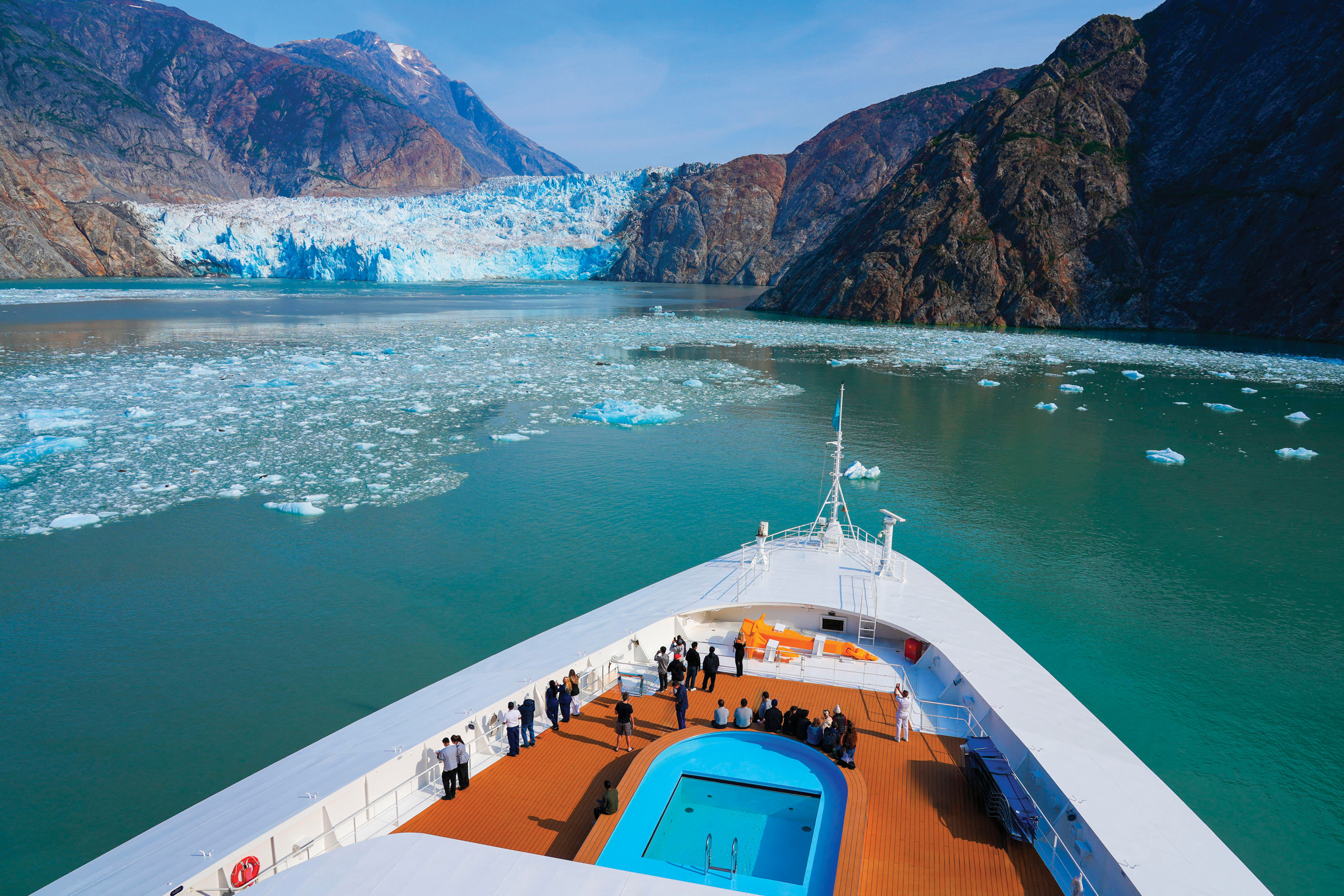
The explanation for this dramatic event emerged later: a colossal landslide, occurring approximately 30 miles away at the terminus of Tracy Arm fjord, a dramatic, narrow channel winding between towering mountains south of Juneau. This landslide originated near the South Sawyer Glacier, an area where retreating glacial ice is believed to contribute to slope instability. The immense scale of the slide was evident in the dramatic 1,580-foot wave run-up recorded on the nearby mountainsides, a figure that ranks among the highest ever documented. As the tsunami radiated outward from the point of impact, it scoured the steep fjord walls, with its residual energy eventually reaching Calvey’s remote beach.
This event is not an isolated incident. Evidence suggests a significant increase in landslide-generated tsunamis in Alaska over the past decade. In 2015, a similar landslide at Taan Fjord, located about 400 miles northwest of Tracy Arm, produced a staggering 630-foot run-up. Furthermore, a slowly creeping landslide near the Barry Glacier in Prince William Sound poses a persistent threat, with the potential to generate a tsunami that could rival, or even surpass, the scale of the Tracy Arm event. This emerging hazard, intrinsically linked to a changing climate, poses a significant risk to coastal communities, vital infrastructure, and the multitude of vessels that navigate these waters, including the large cruise ships that bring nearly two million visitors to Alaska annually.
Calvey had encountered warnings about tsunamis in Alaska’s fjords during her trip preparations, but these were primarily associated with seismic activity, such as the infamous 1958 event in Lituya Bay, Glacier Bay National Park, which caused a landslide and an extraordinary 1,720-foot run-up. The possibility of giant, tsunami-inducing landslides triggered by retreating glaciers was not widely recognized. Calvey now hopes that the Tracy Arm incident will bring greater attention to this underappreciated geological hazard.

The sheer luck involved in the Tracy Arm event is difficult to overstate, particularly given the fjord’s immense popularity. Tracy Arm is a prime destination for Alaska’s tourism industry, drawing over 200 cruise ship visits each summer, carrying thousands of passengers eager to witness the majestic South Sawyer and Sawyer Glaciers calving into the ocean. This stunning natural spectacle within the Tongass National Forest attracts an estimated 500,000 boat-based visitors annually. While numerous vessels were present in the fjord in the days preceding the landslide, the early morning timing of the event meant that traffic was significantly lighter. The closest known vessel, the over-100-passenger National Geographic Venture, was navigating the fjord and en route to the glaciers. Fortunately, due to its position in deep water and approximately 20 miles from the South Sawyer Glacier at the moment of the slide, it remained unharmed. Had the landslide occurred just a few hours later, the Venture would have been much closer to the glaciers, a zone where passengers often disembark onto smaller skiffs to explore the ice formations up close. In such a scenario, the tsunami’s towering waves, laden with icebergs and debris, could have easily overwhelmed and destroyed the tour boat and its skiffs.
Christine and Jeffrey Smith, owners of the 65-foot tour boat the David B, also experienced a stroke of fortune. They had planned to anchor for the night near South Sawyer Glacier with six guests aboard. However, adverse weather conditions prompted them to relocate their anchorage to the neighboring Endicott Arm, some 45 miles away. This decision proved fortuitous, as the tsunami would have struck their intended anchorage mere minutes after the landslide. Even in Endicott Arm, the tsunami’s effects were felt. While preparing breakfast, Christine Smith witnessed 10-foot swells suddenly inundate a shoal and observed an 80-foot vessel struggling against an unusually strong current. The Smiths immediately sent a satellite text to their geologist friend in Washington, Jackie Caplan-Auerbach, requesting her to check seismic stations for any indication of landslides. This message marked the first report of the Tracy Arm tsunami to the outside world.
Caplan-Auerbach, a seismologist and professor at Western Washington University, was in the midst of her morning routine when the urgent text arrived. She promptly began analyzing seismic data from stations near the David B’s location, recognizing the public accessibility of much of this data. However, the sparse distribution of seismometers in the vast and remote region of Southeast Alaska presented a challenge. A sensor located in Angoon, a Tlingit village approximately 60 miles west of the David B, revealed a distinctive seismic signature indicative of a nearby landslide. This clue, shared with colleagues, quickly led scientists to pinpoint the landslide’s origin in Tracy Arm. Caplan-Auerbach understood the gravity of the situation, noting that such a significant tsunami, capable of traveling 45 miles to the David B, implied a massive displacement of water.

Intriguingly, Caplan-Auerbach also observed subtle seismic signals emanating from the slope for several hours preceding the main landslide. While described as "tiny" and likely to have gone unnoticed without the subsequent catastrophic event, these precursory signals were also detected by other seismometers. They ceased abruptly with the collapse of the mountainside. Caplan-Auerbach has dedicated nearly two decades to studying these "precursory" signals, contemplating their potential role in a future landslide warning system. However, she acknowledges the significant challenges involved, stating that landslides are "notoriously difficult to anticipate" due to a complex interplay of factors including rock type, precipitation, and numerous other variables. Furthermore, she cautions that these precursory signals do not precede every landslide event.
The implications of the Tracy Arm landslide extend beyond immediate safety concerns, prompting a broader reevaluation of geological hazards in Alaska. In October, Bretwood "Hig" Higman, an independent geologist working with his nonprofit Ground Truth Alaska, and this reporter visited Portage Lake, an hour southeast of Anchorage. Their objective was to inspect sensors deployed on a slow-moving landslide situated above Portage Glacier. As they navigated the fog-shrouded waters in small packrafts, the distant rumble of a rockslide served as a stark reminder of the unstable mountainous terrain. Higman, a geologist with a keen observational interest, noted the sound with focused curiosity.
In May 2020, Higman and a group of fellow scientists had issued a public warning about a potentially catastrophic creeping landslide near the Barry Glacier in Prince William Sound through an open letter published in The New York Times. This proactive measure, while intended to raise awareness, was met with some local criticism for not being disseminated through official channels, causing understandable concern just before the peak tourism season. The Barry Arm landslide, located about 40 miles north of Portage Lake, is a formidable geological feature. During the summer months, rocks cascade down its loose gravel surface, generating dust plumes and sending debris into the ocean. Nearby, the Barry Glacier actively calves ice into the water. Scientific modeling suggests that a complete collapse of the slope could trigger a massive tsunami, endangering boats, cabins, campsites, and the people within them across a wide area. Even a diminished but still powerful 6-foot wave could impact the nearby city of Whittier, posing a threat to residents along its low-lying shores.

Following the researchers’ open letter, state and federal agencies responded by deploying a comprehensive suite of high-tech monitoring instruments throughout Barry Arm fjord. This array includes weather stations, seismometers, live-feed cameras, radio repeaters, and ground-based radar, all providing real-time data on the unstable slope. An experimental tsunami warning system is also in place, enabling scientists to alert Whittier officials and broadcast warnings to boaters via VHF radio. The data gathered from the Barry Arm project has significantly enhanced the ability to detect and pinpoint more distant landslides, including the recent event in Tracy Arm. The entire initiative represents a substantial investment of millions of dollars in state and federal funding.
As Higman and this reporter paddled across Portage Lake, their reflections mirrored on the water’s surface, Higman elaborated on the factors that make certain Alaskan glaciers, particularly those experiencing rapid retreat, potential sources of geological hazards. Key ingredients include visibly unstable slopes positioned above thinning ice, a sufficiently large body of water to generate a tsunami, and proximity to human populations and infrastructure. Portage Lake, much like Barry Arm, possesses all these characteristics. A Chugach National Forest visitor center is situated on its shores, attracting up to 1,000 visitors daily during the summer months. Many of these visitors board the 140-passenger Ptarmigan tour boat, which regularly circumnavigates the lake. Additionally, the area is served by a nearby road, railway, campgrounds, and hiking trails, all potentially vulnerable to a tsunami’s path.
Upon landing on a narrow stretch of shore, they secured their packrafts to a cliff face, hoping to deter any curious bears. Shouldering their packs in the cool air, they embarked on a hike through dense alder brush and then up steep, verdant tundra. As the fog began to dissipate below, revealing the imposing Portage Glacier, a colossal river of ice nestled between bulging mountains, icebergs dotted the lake where the glacier met the water. However, along its edges, the ice, darkened by debris, appeared to be receding from the mountain walls, giving the glacier a visibly weakened appearance.

Higman explained that this phenomenon could be an example of "debuttressing." Healthy glaciers, through their erosive action, tend to steepen or even undercut adjacent mountainsides. Simultaneously, they exert pressure against these slopes, providing a form of support. However, as glaciers thin, a process occurring globally due to climate change, this buttressing effect diminishes. This loss of support can lead to the collapse of steepened slopes. Climate change also contributes by thawing alpine permafrost and exacerbating extreme rainfall events, both of which can trigger landslides associated with debuttressing. Nevertheless, the precise mechanisms that govern when and if a slope will fail remain elusive. Landslides do not invariably follow glacial retreat, and sometimes they do not occur at all. Although the Barry Glacier has receded from the base of its unstable slope over the past decade or more, the slope itself has not yet experienced a significant slide.
"It’s frustrating that we don’t know more about how these systems work," Higman remarked, gazing down at the retreating glacier meeting Portage Lake. As they ascended higher above the glacier, Higman pointed out fine cracks in the ground, clear indicators of the slope’s instability. These cracks had opened so recently that living heather still bridged them, its desiccated roots dangling precariously. Further cracks appeared as they continued their ascent, leading them to navigate around seemingly bottomless chasms several feet wide. Far below, the Portage Glacier thundered as it calved icebergs into the lake. The tundra abruptly gave way to the most active edge of the landslide. Stretching both above and below, and spanning an area as wide as a football field, the slope presented a chaotic scene of upturned rock and soil, characterized by leaning spires, shattered boulders, and deep, gravelly sinkholes. The occasional sharp crack of tumbling rocks punctuated the otherwise quiet environment. Higman indicated that the entire mass was slowly slumping towards the glacier, moving several meters annually. He believes that the thinning glacier, by debuttressing the slope, is the primary driver of this movement, though other factors may also contribute.
Higman and other researchers share concerns that the slope could catastrophically collapse into the lake in the coming years as the glacier continues to recede from beneath it. This scenario mirrors what transpired at Tracy Arm, where satellite imagery revealed a rapid withdrawal of the South Sawyer Glacier from beneath the doomed mountainside in the weeks and days leading up to its collapse. Higman, Caplan-Auerbach, and several other scientists, led by Dan Shugar of the University of Calgary, recently published a study in the journal Science detailing how the glacier’s retreat critically destabilized the slope, setting the stage for the landslide and subsequent tsunami.

Dennis Staley, a U.S. Geological Survey scientist spearheading the multi-agency effort at Barry Arm, acknowledges that numerous factors can contribute to landslides, including weather patterns and inherent slope weaknesses. While the recent research underscores the link between retreating glaciers and landslides capable of generating tsunamis, Staley stated, "It’s hard to know a specific trigger." Higman concurred, carefully choosing his words, suggesting that "there could be many causes" for the Tracy Arm slide. However, he described the timing of the glacier’s rapid retreat as an "extraordinary coincidence" that heightened immediate concerns regarding Portage.
As they traversed the steep, barren slide, navigating around precariously balanced boulders, dirt and scree shifted underfoot. Higman retrieved an extensometer, a small metal and glass canister he had previously anchored into the rock. "It’s like an electronic tape measure," he explained, using a drill to access its casing and replace its battery. This device continuously records the rock’s movement. While still experimental, Higman expressed hope that visitors’ center staff or he himself could eventually access its data online, particularly during periods of heavy rainfall or accelerated glacial retreat. Ideally, Higman envisions a more extensive network of precise instruments at Portage, similar to the array at Barry Arm. These would be connected to satellites and a government agency capable of activating an alert system at the first sign of accelerating movement, potentially detecting critical precursory signals. Higman highlighted the cost-effectiveness of his modest, locally developed efforts, enabling more instruments to be deployed in a greater number of locations. However, he noted that these rudimentary sensors must be placed "at just the right crack" to accurately measure movement, and for now, they represent the sole monitoring presence at Portage. They continued to traverse the slope, searching for additional sensors, each designed to observe the critical fissures that Higman believes are vital indicators of instability.
A few weeks prior to visiting Portage Lake, the captain of the Ptarmigan tour boat had photographed fresh debris at the base of the slowly moving landslide, an area recently exposed by the receding Portage Glacier. These images were shared with visitor center staff, who then consulted with Higman. Subsequently, an intense multi-day storm delivered 8 inches of rain to the area. After weighing the potential risks, the Forest Service evacuated a school group and staff from the visitor center, according to an agency statement. The Ptarmigan tour boat canceled its operations, citing landslide and tsunami concerns. This adaptive approach may signify a new operational paradigm for navigating the evolving landscape around Alaska’s melting glaciers.

While this adaptability offers a glimmer of hope, Higman pointed out that the Tracy Arm event raises critical questions about how scientists prioritize which slopes to monitor. Visible signs of slope movement, such as those observed at Portage and Barry Arm, are important indicators, but so is the extent of glacial retreat. Higman and other researchers have gathered preliminary data suggesting a correlation between the duration a newly exposed slope remained covered by ice and its likelihood of subsequent sliding. He believes that Endicott Arm and LeConte Bay, two popular fjords south of Tracy Arm, warrant thorough investigation. After all, the Tracy Arm mountainside appeared stable and lacked the obvious warning signs present at Portage, and crucially, it was unmonitored. "As scientists, we need to own up to having totally missed the ball on that one," Higman stated candidly.
The impacts of climate change are increasingly evident in Alaska’s dramatic landscapes, prompting a reevaluation of geological hazards and their potential to disrupt both human activities and delicate ecosystems. The Tracy Arm landslide serves as a stark reminder of the profound and sometimes unpredictable forces at play, urging continued scientific inquiry and proactive risk management in this rapidly transforming region.