Rocky Gerung
A stray ember, fanned by fierce winds, ignited a devastating blaze that swept across the Spokane River from Riverside State Park, engulfing the Indian Trail neighborhood and triggering mass evacuations. What began as a localized incident quickly escalated into a catastrophic event, leveling homes and leaving a trail of destruction in Spokane, Washington. While authorities have arrested an individual on suspicion of arson in connection with the fire’s origin, the immediate aftermath has been defined by the relentless spread of flames and the urgent need for disaster response.
As of Monday afternoon, the Old Trails Fire, along with two other significant blazes – the Autumn Lane Fire in the Suncrest area and the Fairview Fire in Mead – continued to rage, their perimeters collectively encompassing over 10,000 acres by Tuesday, according to data from Watch Duty, an app that aggregates human-reported wildfire information. The grim toll included the loss of between 700 and 1,100 structures across these three fires, a stark testament to the ferocity of the inferno. Spokane Mayor Lisa Brown characterized the situation as "the worst natural disaster the region has faced," underscoring the profound impact on the community.
These conflagrations underscore a critical and increasingly prevalent phenomenon: fires burning within the wildland-urban interface (WUI). This term, as defined by fire experts and FEMA, describes areas characterized by a high risk of wildfire where human habitations are interspersed with combustible natural fuels such as trees, grasses, and brush, or the zone where undeveloped land meets human settlements. While often associated with remote mountain towns or isolated rural properties, the Old Trails Fire has dramatically illustrated that the WUI extends deep into suburban landscapes, challenging long-held perceptions of where such threats are most acute.
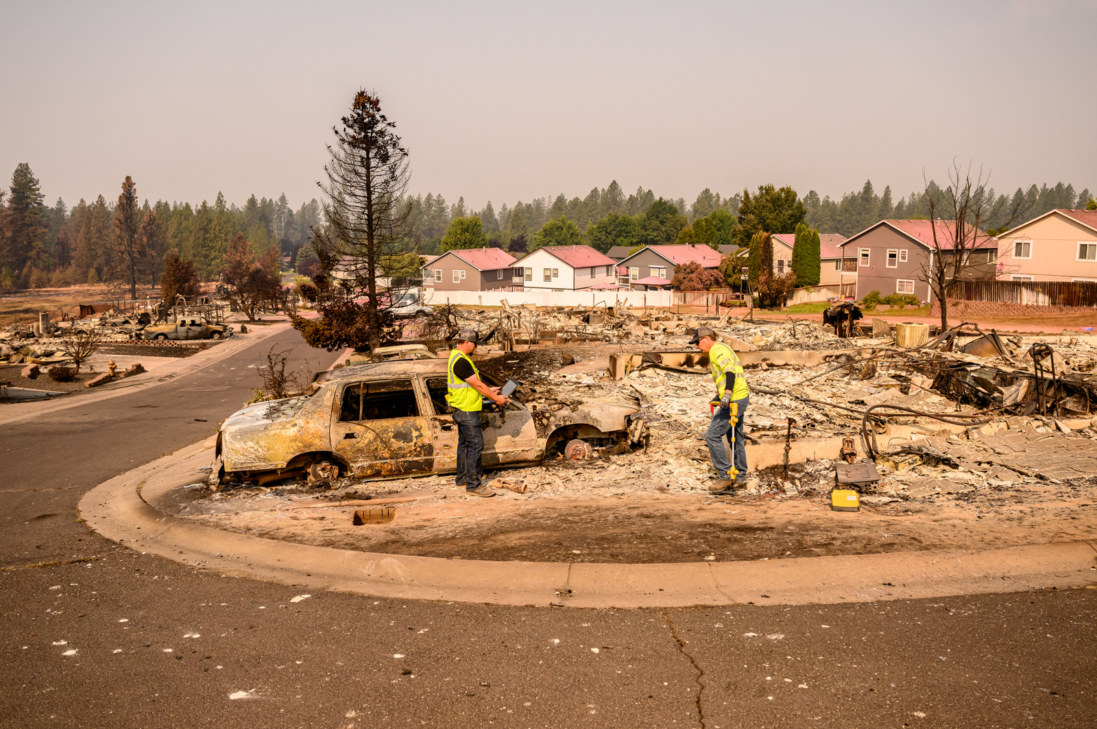
The destructive pattern seen in Spokane is not an isolated incident; recent years have witnessed similar urban-wildfire interfaces igniting and rapidly consuming residential areas. The Eaton and Palisades fires in the Los Angeles area in January 2025 and the 2021 Marshall Fire in Colorado, which became the state’s costliest wildfire, serve as sobering precedents. Each of these events was sparked on the periphery of suburban communities and, propelled by powerful winds, surged into neighborhoods, demonstrating the alarming speed at which densely populated areas can be consumed under the right meteorological conditions.
The Indian Trail neighborhood, largely developed between the 1980s and 2010s, represents a significant portion of a broader trend of development in fire-prone regions across the American West. Its character – a mosaic of sports complexes, schools, churches, a skatepark, grocery stores, manicured lawns, and tidy homes – mirrors countless other suburban enclaves. While residents enjoy access to nearby state park trails, the area is not typically perceived as remote or inherently wild. Its proximity, a mere 15-minute drive from downtown Spokane, a metropolitan area of over 600,000 people, further complicates the definition of the WUI.
Data from the U.S. Forest Service reveals that nearly one-third of all housing in the United States is now situated within the wildland-urban interface, a figure that has grown in tandem with the expansion of human settlements into these higher-risk zones. Compounding this vulnerability, climate change is increasingly priming landscapes for more frequent and intense wildfires, placing these communities in ever greater peril.
FEMA maps identify a significant portion of northern Spokane, extending eastward towards the major arterial street of Division Street, as being at risk from ember-driven wildfires. Further analysis by the Forest Service indicates that homes in Spokane County face a higher fire risk than those in 82% of counties nationwide. Intriguingly, some of the areas most severely impacted by the Old Trails Fire were previously classified as having moderate or even low fire risk, highlighting the limitations of static risk assessments in the face of dynamic environmental conditions.

In Spokane, the immediate trigger for the rapid escalation of the Old Trails Fire was the presence of exceptionally high winds. The National Weather Service issued a rare "particularly dangerous situation" designation for the first time in Washington state history, a critical warning that underscored the extreme fire behavior anticipated. These same powerful winds were not confined to Spokane; they fueled a surge of additional wildfires across north-central Washington. Among these were the Sinlahekin Fire, which had grown to nearly 74,000 acres by August 3rd, the Little Giant Fire, which rapidly expanded and even spotted across Lake Chelan over the weekend, and the Kaiser Canyon Fire on the Colville Indian Reservation, which, as of the latest reports, had consumed over 136,000 acres.
The pervasive smoke from these widespread fires has now drifted across the northern Rockies, blanketing communities with a haze reminiscent of the conditions still gripping Spokane. Across the Western United States, communities are confronting the stark reality of wildfire preparedness, perhaps with renewed urgency, especially those whose neighborhoods were once considered impervious to such catastrophic events. The fires in Spokane serve as a potent reminder that the wildland-urban interface is a fluid concept, and the threat of wildfire is an evolving challenge that demands continuous adaptation and proactive mitigation strategies. The scale of destruction necessitates a reevaluation of land-use planning, building codes, and community preparedness measures, particularly as the climate continues to shift and the conditions conducive to extreme wildfire events become more prevalent. The resilience of communities like Spokane will be tested not only by the immediate recovery efforts but also by the long-term implications of living in an era of heightened wildfire risk.