Rocky Gerung
An ember, then several, ignited the Old Trails Fire, which rapidly crossed the Spokane River from a nearby state park into the Indian Trail neighborhood, triggering mass evacuations on Saturday afternoon in Spokane, Washington. Although the blaze originated near the forested Riverside State Park, allegedly set by an arsonist who was subsequently arrested, it swiftly consumed homes in Spokane’s northwest quadrant. As of Monday afternoon, local reports indicated that between 700 and 1,100 structures were lost across three ongoing fires: the Old Trails fire, the Autumn Lane Fire in the Suncrest area, and the Fairview Fire in Mead. By Tuesday, these fires collectively encompassed over 10,000 acres, according to data from Watch Duty, an application that aggregates human-reported fire information. Spokane Mayor Lisa Brown characterized the events as "the worst natural disaster the region has faced."
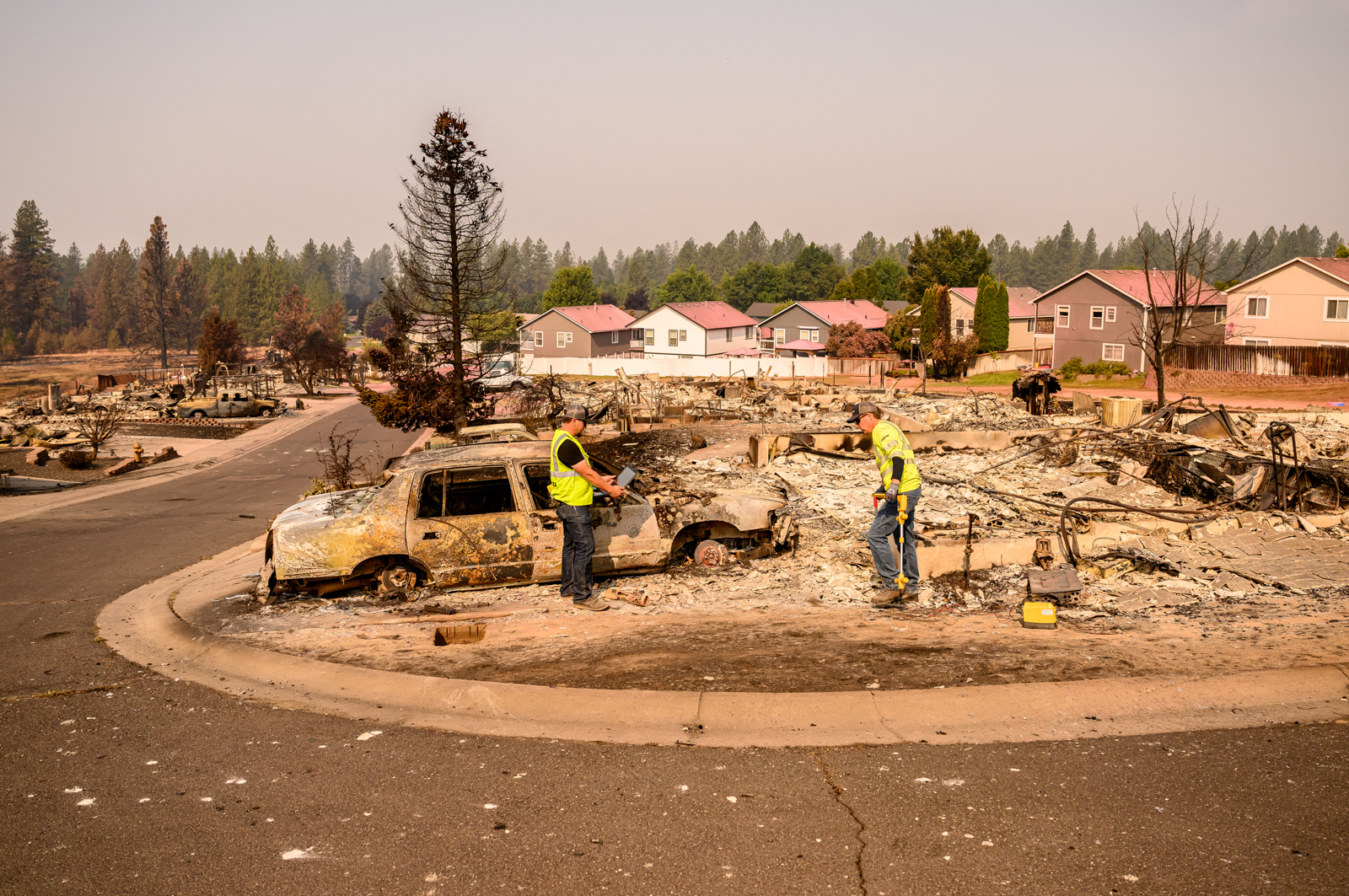
These destructive fires, like many that have ravaged communities, are burning within what fire experts term the "wildland-urban interface" (WUI) – areas where human development meets landscapes prone to high fire risk, characterized by combustible elements like trees, grasses, and brush. FEMA defines this interface as the zone between undeveloped land and human settlements. While the term often evokes images of mountain towns or rural enclaves nestled within forests, far from urban centers, the Old Trails Fire demonstrated that this interface extends into suburban environments. This phenomenon is not new; similar urban-wildfire conflagrations have occurred in recent years, including the Eaton and Palisades fires in the Los Angeles area in January 2025 and the 2021 Marshall Fire, which became the costliest wildfire in Colorado’s history. In each instance, fires ignited on the outskirts of suburban areas were propelled into neighborhoods by strong, gusty winds, underscoring the rapid vulnerability of residential areas under specific weather conditions.
The Indian Trail neighborhood, a suburban community largely developed between the 1980s and 2010s, represents a significant portion of a broader trend of development in fire-prone regions across the Western United States. The areas impacted by the fire are typical of many communities in the region, featuring a large sports complex frequented by generations of young athletes, churches, schools, a skatepark, grocery stores, well-maintained lawns, and comfortable homes. While not considered overtly wild, the neighborhood’s appeal is partly derived from its proximity to state park trails. Located approximately 15 minutes from downtown Spokane, the second-largest city in Washington with a metropolitan population exceeding 600,000, Indian Trail highlights how the wildland-urban interface can be intimately connected to urban centers.

Current data reveals that nearly a third of all housing in the United States is situated within the wildland-urban interface, a statistic underscored by 2020 Forest Service research. As climate change increasingly primes landscapes for more frequent and intense wildfires, these densely populated interface areas face escalating threats. FEMA maps indicate that much of northern Spokane, extending eastward towards the major arterial street Division Street, is considered at risk from ember-driven wildfires. Further analysis from Forest Service maps shows that homes in Spokane County face a higher fire risk than in 82% of counties nationwide. However, it is noteworthy that some areas that experienced significant damage were previously classified as having only moderate fire risk, and large portions of the evacuated zones were designated as low risk, emphasizing the unpredictable nature of these events.
In Spokane, extreme winds significantly amplified the fire risk, leading the National Weather Service to issue a "particularly dangerous situation" designation for the first time in Washington state history. These same powerful winds that fueled the Old Trails Fire also contributed to the outbreak of several other wildfires across north-central Washington. Among these were the Sinlahekin Fire, which by August 3rd had grown to nearly 74,000 acres; the Little Giant Fire, which spread across Lake Chelan over the weekend; and the Kaiser Canyon Fire on the Colville Indian Reservation, which, at the time of reporting, had consumed over 136,000 acres. The resulting smoke from these extensive fires has drifted across the northern Rockies, blanketing communities much like those currently battling the blazes in Spokane. As communities throughout the West grapple with the increasing reality of wildfire threats, the events in Spokane serve as a stark reminder, particularly for those whose neighborhoods previously felt insulated from such dangers.