Rocky Georgio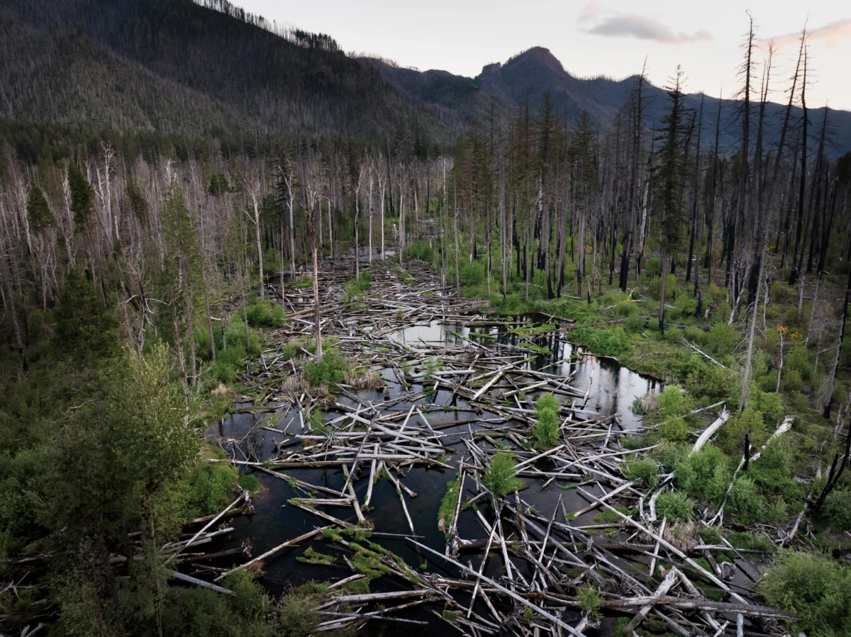
An hour’s drive east of Eugene, Oregon, Quartz Creek cascades down the slopes of the Western Cascades, widening into a valley before merging with the McKenzie River. This once-dynamic landscape, shaped by geological forces and natural processes, is now the site of an ambitious restoration project employing a novel technique known as Stage 0, aiming to reverse decades of human alteration and re-establish a more resilient ecosystem.
The geological history of the region laid the groundwork for a complex river system. Approximately 12 million years ago, volcanic activity thrust the Earth’s crust upward, forming the initial rough outline of the Western Cascades. Over eons, water and ice meticulously sculpted this uplifted terrain, carving deep canyons and transporting eroded sediment to gentler valley floors. In these broad depositional zones, like the area surrounding Quartz Creek, water naturally fanned out, creating intricate wetlands crisscrossed by a network of branching channels. This intricate aquatic environment was a haven for species like Chinook salmon, bull trout, and Pacific lamprey, which hatched and thrived in the slow-moving waters before many embarked on migrations to the Pacific Ocean and returned to enrich the riparian forests with marine-derived nutrients. Natural disturbances such as windstorms, wildfires, and landslides were integral to this ecosystem, toppling trees that beavers then ingeniously incorporated into dams, forming ponds and further diversifying the watercourses.
This constant, dynamic flux, far from being chaotic, fostered a unique form of stability. It prevented any single channel from dominating, preserving a rich mosaic of deep pools, turbulent confluences, sandy bars, and gravel beds. This diverse habitat supported an equally varied array of plant and animal life, which, in turn, sustained human populations. Indigenous tribes, including the Kalapuya, Mollala, and Warm Springs peoples, historically inhabited these lands, utilizing the area’s resources for fishing, hunting, and gathering throughout the year.
The mid-19th century marked a significant turning point with the arrival of Euro-American settlers. By 1860, tribal lands were forcibly consolidated onto reservations, and settlers began to exploit the region’s timber resources. Streams like Quartz Creek, with their inherently swampy floodplains and unpredictable flows, posed challenges to these new land-use practices. In response, newcomers engineered the landscape, digging drainage ditches, constructing berms, and elevating roadbeds. This intervention had a profound effect, drawing the creek’s many threads into a more confined, single channel. The valley floor was fundamentally reshaped; the concentrated flow deepened the creek’s channel while the adjacent floodplain grew drier. Fewer downed trees reached the water, and the accelerated currents flushed sediment downstream, diminishing the calm pockets essential for fish. Consequently, species like Pacific lamprey saw a decline, and Chinook salmon and bull trout disappeared from the area altogether.

The transformation of Quartz Creek from a naturally braided system into a more channelized form required considerable labor, a reflection of the persistent human impulse to control and simplify natural landscapes. Today, a new group of individuals, armed with modern technologies such as excavators, LiDAR, and GPS mapping, are working to reverse these historical interventions, aiming to re-establish the valley’s ecological complexity.
This endeavor is the latest phase of a broader river restoration initiative within the McKenzie River watershed, which commenced a decade ago. It champions a groundbreaking approach called Stage 0, designed to convert formerly canalized streams back into dynamic wetland-stream complexes by re-grading portions of the valley floor. This process is inherently disruptive, necessitating significant alteration of the existing landscape. As geomorphologist Gordon Grant aptly described it, "It’s a full-on field experiment," acknowledging the novelty and scale of the undertaking, with long-term studies still in their nascent stages.
The McKenzie River holds significant cultural and recreational importance, cherished by boaters, anglers, and environmentalists. The application of this highly invasive restoration technique has naturally sparked debate, with some expressing reservations about its experimental nature. However, proponents view it as a critical opportunity to mend past ecological damage before it becomes irreversible.
The McKenzie River watershed historically supported a substantial population of Upper Willamette River chinook salmon, a species of immense ecological and cultural significance to the region and integral to the health of the Columbia River Basin. This native fish, now listed as threatened, has seen its population plummet to less than 2% of its historic abundance in the McKenzie, representing the largest remaining wild population and a crucial hope for the species’ recovery. Projections suggest that without intervention, these salmon could face extinction by 2050. Elizabeth Goward, community engagement manager for the McKenzie River Trust, emphasizes the urgency: "We know we don’t know everything. But if we don’t act now, we could lose this species."
Brian Cluer, a fluvial geomorphologist, developed an early interest in landscapes from the unique perspective of an airplane pilot. His observations of remote river valleys, which appeared less like defined channels and more like expansive wetlands, challenged the prevailing scientific understanding of river systems. Influential early geomorphologists, such as Luna Leopold, had characterized undisturbed streams as primarily single, meandering channels. This archetype, while influential, began to be questioned as research accumulated.

In the 1990s, hydrologist David Rosgen’s Natural Channel Design (NCD) method gained traction. This approach, based on established studies and detailed site assessments, aimed to guide impaired streams back to a stable, natural form. The rise of NCD coincided with federal regulations allowing for habitat mitigation, fostering a burgeoning river restoration industry. While Rosgen’s designs allowed for some natural evolution, many NCD projects resulted in hardened banks, limiting the stream’s dynamism and sometimes failing under flood conditions. Cluer noted that many of these projects fell short of their ecological objectives.
Further challenging the single-channel paradigm, a 2008 study published in Science re-examined early geomorphological research. The authors concluded that many of the seemingly "natural" mid-Atlantic streams studied previously had been significantly altered by the widespread construction of mill dams by Euro-American settlers, indicating that the single-channel archetype was, in fact, a product of human manipulation. Concurrently, researchers across the Western U.S. employed advanced technologies like LiDAR and delved into historical records, revealing that many pre-colonial streams likely exhibited a more complex, multi-threaded wetland structure. Integrating this growing body of evidence with their field observations, Cluer and fellow geomorphologist Colin Thorne developed an updated stream evolution model, identifying a "Stage 0" condition—a wet valley floor intricately webbed with streams—as a fundamental starting point.
Meanwhile, Kate Meyer, a fish biologist formerly with the Forest Service, was working on habitat restoration in the McKenzie watershed, focusing on Deer Creek. This tributary had suffered from decades of logging and "stream cleaning," a practice prevalent in the 1960s and 70s that involved removing natural wood debris from streams. This removal eliminated vital habitat complexity, and the stream was confined to a straightened, high-velocity channel, described by Meyer as "essentially a firehose."
Meyer’s team initially employed standard restoration techniques, such as adding logjams to slow water and trap sediment. However, these efforts yielded limited success, with high-energy flows often dislodging the wood and sediment accumulation taking decades. Meyer became aware of an alternative approach being tested in eastern Oregon: rather than improving existing channels, the focus was on eliminating them entirely. This concept gained momentum around 2002 when fisheries biologist Paul Powers observed a landslide-induced restoration event at a previous project. The landslide had dispersed the stream across the valley floor, creating slower flows, increased wetlands, and improved fish habitat. Powers began experimenting with replicating this outcome at Whychus Creek in central Oregon, intentionally directing flows out of the channel and onto the floodplain.
In 2014, Meyer attended a restoration symposium where Cluer and Thorne presented their Stage 0 framework. "It was a total epiphany moment," Meyer recalled, recognizing the theoretical validation of their practical observations. When Powers joined the Deer Creek team in 2016, he advocated for implementing Stage 0. Meyer harbored reservations, questioning the radical act of "burying the stream."

Their initial efforts involved dismantling levees and using the material to fill sections of the channel. The stream immediately responded by spreading across the floodplain, forming multiple slow-moving channels and deeper pools. This contrasted sharply with the unfilled reaches where conditions remained largely unchanged. Cluer and Thorne, upon visiting these projects, were astonished to see their theoretical models translated into practice.
Encouraged by the initial successes at Deer Creek—where Chinook salmon were observed spawning in 2017 for the first time since 1993—Meyer and her team embarked on a larger project in 2018 on the South Fork of the McKenzie. This 200-acre endeavor aimed to restore the tributary to Stage 0 conditions, building upon a refined methodology developed by practitioners like Meyer and Powers.
The process begins with identifying suitable sites, typically low-gradient, historically depositional valleys where streams can naturally spread without impacting infrastructure. Understanding landscape history, often through clues like relic wetlands or ancient tree stands, is crucial for approximating the valley floor’s original shape. LiDAR technology provides precise topographic data for comparison with the target profile, guiding the grading plan. Fish are relocated to downstream areas, and the river is temporarily diverted. Heavy machinery then reshapes sections of the valley floor, filling channels and removing artificial levees. Large woody debris is strategically placed across the floodplain, partially buried or left to move naturally, serving both to create habitat and to slow water flow as vegetation re-establishes. Finally, the diversion is removed, allowing the stream to disperse across the valley floor and initiate the process of riverscape reconstruction.
The construction phase of a Stage 0 project can be visually jarring. Visiting Quartz Creek in August, the landscape appeared devastated, with a muddy stream flowing alongside hundreds of acres of dusty soil strewn with logs and slash. "People say, ‘This isn’t Stage 0, it’s Ground Zero—it looks like you nuked the place,’" Thorne commented. However, Lara Colley, floodplain restoration projects manager for the McKenzie Watershed Council, viewed the site with optimism, noting the distribution of thousands of logs across the floodplain. These logs, sourced from areas where trees were thinned for habitat or removed after wildfires, were integral to the restoration plan.
The collaborative effort on Stage 0 projects has grown since the Forest Service and McKenzie Watershed Council began working together in 2016. The Eugene Water and Electric Board (EWEB) and the McKenzie River Trust have joined the leadership, bringing diverse perspectives and resources that help sustain the work amidst federal budget constraints. Goward described this collaboration as an "ecosystem."

For EWEB, a public utility supplying drinking water to the Eugene metropolitan area, stream restoration is intrinsically linked to safeguarding water quality. Quartz Creek’s high sediment loads during flood events had historically taxed EWEB’s filtration systems. By allowing sediment to settle out on the expanded floodplain, the Stage 0 project aims to reduce filtration costs and chemical usage. Susan Fricke, EWEB’s Water Resources Supervisor, views the river as essential infrastructure, emphasizing that proactive prevention is more effective than reactive mitigation.
The natural resources department of the Confederated Tribes of Warm Springs has provided valuable input, recognizing Stage 0’s holistic approach to restoring river wetland corridors. Tribal fisheries biologist Logan Bodiford stated that the project aligns with the Tribes’ goals for sustainable fisheries and hopes it will better enable tribal members to exercise their treaty rights and access culturally significant resources.
The design for Quartz Creek was spearheaded by Kate Meyer, who co-founded a restoration consulting firm after leaving the Forest Service. Franklin-Clarkson Timber Co., the private timber company owning much of the land, granted access through a 50-year stewardship easement. The National Oceanic and Atmospheric Administration provided significant funding through a $7.6 million grant from the Infrastructure Investment and Jobs Act. The physical work of reshaping the land and placing logs was executed by Haley Construction, a family-run company with a long history in timber and a growing focus on river restoration.
Managing the complex logistics of the Quartz Creek project, which involved a large crew, extensive materials, and a dynamic river, presented considerable challenges. Randy Haley, co-owner of Haley Construction, likened the process to directing an orchestra. His daughter, Ashley Haley, project manager, noted the demanding nature of restoration work but emphasized its rewarding impact on the community and wildlife. The dedication of the crew, with some long-term employees returning specifically for restoration projects, highlights the deep commitment to this work. Haley Construction’s evolution from a timber-focused company to one heavily involved in environmental restoration mirrors broader shifts in societal priorities and a recognition of the need to address past environmental impacts.
The expertise gained in logging and working with wood in forest and waterway environments has proven invaluable in floodplain restoration. Randy Haley acknowledged that while loggers were performing their jobs as they understood them at the time, the company now leverages that knowledge to repair some of the industry’s historical impacts.

Witnessing the heavy machinery at work on the scarred valley floor of Quartz Creek, particularly with the backdrop of the 2020 Holiday Farm Fire that devastated over 173,000 acres in the surrounding mountains, underscored the scale of ecological challenges. Ironically, the fire played a crucial role in advancing the Stage 0 work. It provided an abundant source of logs and made the heavy construction more socially acceptable, as working in a scorched landscape felt less intrusive than in a pristine forest. More significantly, the fire revealed a compelling co-benefit of Stage 0: preliminary observations at the South Fork of the McKenzie, the largest Stage 0 project at the time, indicated that the restored area burned in patches, offering refuge for wildlife and promoting faster forest recovery. In some sections, the wider water expanse even acted as a firebreak. This unexpected contribution to fire resilience was a significant revelation for project leaders.
As heavy rains drenched the Western Cascades in late 2025, significant wood movement was observed in the restored Deer Creek reach. While this indicated a more dynamic system, it also raised concerns about stretches where logs were washed out, potentially leading the river to re-channelize. In a healthy, intact system, floodwaters would replenish wood from the surrounding forest. However, decades of logging have reduced the availability of large downed wood in the region, posing a challenge to long-term restoration success.
The initial assumption that a single intervention would suffice has been revised; river systems are nested within larger ecological contexts, and processes like wood and gravel recruitment are still influenced by logging and dams. This realization underscores the need for ongoing stewardship, monitoring, and adaptive management of restored sites.
The Stage 0 approach, while visually disruptive during construction, offers a compelling vision of ecological renewal. Advocates emphasize that the goal is not to replicate a pre-settlement landscape but to empower natural processes to continually shape and reshape the riverscape, fostering greater biodiversity and resilience in the face of climate change. Critics, however, question the feasibility of recreating historical Stage 0 conditions, arguing that such complex wetland-stream networks may have been limited to specific, low-gradient environments. David Rosgen, a proponent of NCD, believes Stage 0 can be effective in certain contexts but cautions against its universal application, suggesting that meandering channels might be more stable and ecologically beneficial in steeper terrains like Quartz Creek.
Gordon Grant, a retired research hydrologist, draws parallels between the enthusiasm surrounding Stage 0 and the earlier embrace of NCD, noting a recurring "bandwagon effect" in restoration. Having dedicated his career to studying how Western Cascades streams respond to various disturbances, Grant views the current Stage 0 projects on the McKenzie as "novel geosystems" and valuable experiments, but emphasizes the need for careful study before widespread implementation. He raises concerns about the potential risks associated with mobilized logs during severe floods, which could damage infrastructure and pose safety hazards, highlighting that the "potential for mischief has not been fully reckoned with."

The power of floodwaters, Grant explains, is immense, capable of transforming entire landscapes. He stresses that the river observed during low or moderate flows is vastly different from its behavior during extreme flood events, and the 100-year flood risk, though statistically low each year, carries significant potential consequences. The decision of which risks are acceptable, Grant notes, often depends on whose perspectives are represented at the table, observing that current restoration efforts are largely driven by a desire to improve conditions for fish.
Despite the challenges and uncertainties, research suggests that Stage 0 projects can indeed create beneficial habitats. Studies indicate an increase in low-velocity rearing areas for fish, a significant expansion of valley floor wetness, and a boost in macroinvertebrate production, all vital components of aquatic food webs. These projects also hold promise for species like the Pacific lamprey, a culturally significant fish whose populations have declined dramatically.
However, not all findings are unequivocally positive. Researchers have observed a tendency for water temperatures to rise in restored areas, and while sediment composition shifts can benefit lamprey, they may pose challenges for salmon. eDNA analysis has also indicated an increase in overall aquatic biodiversity, which includes both native and invasive species.
The long-term trajectory of these restored sites remains a critical question. While construction is rapid, the true restoration unfolds over years and decades. Monitoring of Upper Willamette River chinook populations after the South Fork Stage 0 project showed an initial surge in spawning beds, but these numbers have since fluctuated. Luke Whitman, leading the monitoring effort, suspects that upstream dam management, which limits natural scour flows, may be hindering the continued activation of new channels. He advocates for creative solutions, including adaptive dam operations, alongside restoration efforts.
In the final weeks of 2025, heavy rains in the Western Cascades led to significant wood movement in Deer Creek, showcasing both the dynamic potential and potential vulnerabilities of Stage 0 projects. The displacement of logs without sufficient replenishment from the surrounding landscape could, over time, lead to re-channelization. This highlights the ongoing need for long-term stewardship and adaptive management, acknowledging that restoration alone cannot fully compensate for the impacts of historical land-use practices.

Colin Thorne agrees that "there aren’t any one-and-dones for rivers," but emphasizes that Stage 0 projects are inherently resilient, capable of being rearranged and repaired by nature over time, though the ultimate trajectory remains uncertain.
Returning to Quartz Creek in late January, the landscape, while still bearing the marks of reconstruction, presented a changed scene. Clear water now flowed through braided streams that parted around logjams and lapped at newly deposited sand. The unpredictability inherent in such complex systems, as noted by Gordon Grant, represents not just a warning but a promise of possibility. The success of these projects hinges on a collaborative approach, where humans work alongside natural forces to shape an evolving riverscape.
The devastation wrought by the Holiday Farm Fire served as a stark reminder of the region’s vulnerability to climate change and the escalating wildfire threat. Yet, the emergence of new grass through slash piles at Quartz Creek offered a symbol of resilience and renewal. As Goward observed, "Everything around us is changing. What we’re trying to do is restore the river’s ability to change with it." This adaptive capacity, fostered by a more complex and dynamic river system, offers a pathway toward a more resilient future for the McKenzie River watershed and its inhabitants.