Rocky Georgio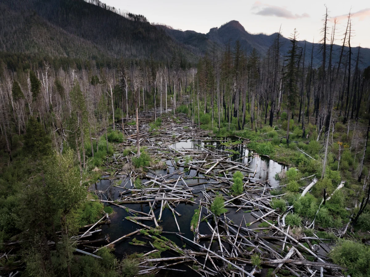
An hour’s drive east of Eugene, Oregon, Quartz Creek cascades down the Western Cascades, widening into a valley before merging with the McKenzie River. This picturesque scene belies a complex geological and ecological history, one that modern restoration efforts are attempting to rewrite. The genesis of this landscape, approximately 12 million years ago, involved the Earth’s crust thrusting upward, buckling to form the nascent Cascade Mountains. Over eons, the relentless forces of rain and ice sculpted this uplifted rock, carving deep canyons and depositing eroded sediment into broader, gentler valleys. These depositional zones, like the section of Quartz Creek observed, naturally fostered wetlands crisscrossed by intricate, branching channels. In this dynamic environment, species such as Chinook salmon, bull trout, and Pacific lamprey thrived, their life cycles intertwined with the ebb and flow of the water and the nutrients they brought back from the ocean. Natural disturbances like windstorms, wildfires, and landslides toppled trees, which beavers ingeniously transformed into dams, creating ponds and further diversifying the aquatic habitats.
This seemingly chaotic flux, however, sustained a profound ecological stability. It prevented any single channel from dominating, maintaining a rich mosaic of deep pools, swift confluences, sandy bars, and gravel beds, interspersed with slow side-channels. This varied environment supported an equally diverse array of plant and animal life, which in turn sustained human populations. Indigenous peoples, including the Kalapuya, Mollala, and Warm Springs tribes, historically inhabited these lands, utilizing the rich resources for sustenance and cultural practices, often migrating seasonally to fish, hunt, and gather in these valleys.
The mid-19th century marked a significant turning point with the arrival of Euro-American settlers. By 1860, federal policies had forcibly relocated many Indigenous tribes to reservations, including descendants who now form the Confederated Tribes of Grand Ronde, Confederated Tribes of Siletz Indians, and Confederated Tribes of Warm Springs. Settlers then began to exploit the region’s timber resources. Streams like Quartz Creek, with their often swampy floodplains and unpredictable flows, presented obstacles to development. In response, newcomers implemented a series of interventions: digging drainage ditches, constructing berms, and raising roadbeds. This process, akin to channeling a river’s multiple threads into a single cord, dramatically altered the valley’s character. The concentrated flow deepened the creek’s channel, while the surrounding floodplain became drier, leading to fewer fallen trees entering the water. Accelerated currents then flushed sediment downstream, diminishing the calm areas crucial for fish habitat, causing lamprey populations to decline and leading to the complete disappearance of Chinook salmon and bull trout.
The labor involved in transforming Quartz Creek’s wild flow into a more controlled channel was considerable. Standing on a bridge overlooking the creek, observing a modern-day crew employing excavators, LiDAR, and GPS mapping, one could only ponder the scale of both past and present human endeavors. These contemporary efforts, however, aim to reverse the ecological damage inflicted by earlier generations, seeking to re-establish the valley’s natural hydrological complexity.

This project represents the latest phase in a decade-long river restoration initiative within the McKenzie River watershed, employing a novel approach known as "Stage 0." This method seeks to transform formerly canal-like channels back into dynamic wetland-stream complexes by re-grading significant portions of the valley floor. It is a bold and disruptive process, requiring substantial alteration of the existing landscape. The long-term ecological consequences of this approach are still under study, and its implementation on this scale is unprecedented, prompting geomorphologist Gordon Grant to aptly describe it as "a full-on field experiment." The McKenzie River, cherished by boaters, anglers, and environmentalists alike, has become a focal point for this innovative, albeit invasive, restoration technique, sparking debate between those who advocate for caution and those who see it as a critical opportunity to heal a damaged ecosystem before it is too late.
The McKenzie River historically supported an estimated 110,000 Upper Willamette River Chinook salmon, a species of immense ecological and cultural importance to the region and the broader Columbia River Basin. Today, this population represents less than 2% of its historic abundance, yet it remains the largest remaining wild population and the best hope for the species’ recovery. Projections indicate that without intervention, this population could face extinction by 2050. Elizabeth Goward, community engagement manager for the McKenzie River Trust, acknowledges the inherent uncertainties, stating, "We know we don’t know everything. But if we don’t act now, we could lose this species."
Brian Cluer, a fluvial geomorphologist, began his career with a fascination for the land viewed from above, developing an appreciation for the intricate ways rivers shape the Earth’s surface. His academic training, influenced by pioneers like Luna Leopold, emphasized a model of undisturbed streams as single, meandering channels. This archetype informed restoration goals and the collective imagination, shaping the common perception of a pristine river as a winding ribbon of clear water. In the 1990s, hydrologist David Rosgen popularized the Natural Channel Design (NCD) method, which used formulas derived from these studies and site assessments to guide the reshaping of impaired streams into stable forms. This era also saw the rise of mitigation banking, where developers could offset environmental impacts by restoring habitats elsewhere, fueling the growth of the river restoration industry into a multi-billion-dollar sector. While Rosgen’s designs allowed for some natural evolution, practitioners often fortified stream banks with riprap and boulders, inadvertently locking channels in place. Some of these projects failed spectacularly when floodwaters overwhelmed the fixed structures, and overall, Cluer observed that many NCD projects fell short of their ecological aspirations.
Cluer’s extensive aerial observations, however, revealed a different natural landscape – one that was far wilder, broader, and less defined than the single-channel model suggested. He noticed remote river valleys resembling vast wetlands rather than distinct waterways, sparking his innovative thinking. This intuition was scientifically validated in 2008 by a study published in Science. The researchers revisited the streams studied by early geomorphologists and discovered that their perceived "natural" state was, in fact, the result of historical human manipulation, specifically the widespread construction of mill dams by Euro-American settlers starting in the late 1600s. These dams had significantly altered valley floors, making the single-channel archetype an artifact of human intervention.
Concurrently, researchers across the Western U.S. and beyond were employing new technologies like LiDAR and delving into historical records to reconstruct the past conditions of landscapes. Their findings converged: many pre-colonial streams likely existed as multi-threaded wetland systems rather than simple winding ribbons. Integrating this growing body of research with their practical experiences, Cluer and fellow geomorphologist Colin Thorne developed an updated stream evolution model. Their new framework began not with a single channel but with a wet valley floor intricately webbed with streams, a state they termed "Stage 0."

While Thorne and Cluer were formulating their theoretical framework, fish biologist Kate Meyer, then with the Forest Service, was tasked with improving fish habitat in the McKenzie watershed. Her team focused on restoring Deer Creek, a tributary that, like Quartz Creek, had suffered decades of logging and a misguided practice called "stream cleaning" in the 1960s and ’70s. This effort, intended to improve river health, involved removing logs and debris, effectively eliminating wood from the system. Furthermore, berms confined the stream to a straightened, high-velocity channel, which Meyer described as "essentially a firehose."
Collaborating with the McKenzie Watershed Council, Meyer’s team initially planned to restore the creek by adding wood to the channel, using logjams to slow water and trap sediment. This was a standard practice at the time, but the results were consistently disappointing, with high-energy streams often dislodging the wood, and sediment accumulation taking decades even when logjams remained intact. Meyer, however, was aware of an alternative approach being tested in eastern Oregon: instead of working within existing channels, the strategy involved eliminating them entirely. This idea gained traction in 2002 when fisheries biologist Paul Powers observed a Natural Channel Design restoration project in the Siuslaw National Forest that had been impacted by a landslide. While project leaders viewed the landslide as a setback, Powers recognized that the displaced earth had dispersed the stream across the valley floor, creating slower flows, increased wetlands, and valuable fish-rearing habitat. He began replicating this outcome at Whychus Creek in central Oregon, intentionally directing flows out of the channel and onto the floodplain.
In 2014, Meyer attended a river restoration symposium where Cluer and Thorne presented their Stage 0 research. She described it as an "epiphany moment," seeing the practical concepts she and her colleagues were working with articulated from a theoretical standpoint. When Powers joined the Deer Creek team in 2016, he proposed implementing Stage 0 there. Meyer expressed both excitement and trepidation, questioning, "You mean we’re just going to bury the stream?"
Their initial efforts involved dismantling levees and using the material to fill sections of the channel. The stream immediately began to spread across the floodplain, forming multiple slower-moving channels and deeper pools. In contrast, the unfilled sections showed little change. When Cluer and Thorne visited these projects, they were astonished to witness their theories being put into practice, with Thorne remarking, "Oh my goodness, these people are actually doing it." Emboldened by this support and the positive outcomes in Deer Creek—Chinook salmon were observed spawning there in 2017 for the first time since 1993—Meyer and her team embarked on a larger project. In 2018, they began a Stage 0 restoration of a 200-acre stretch of the South Fork of the McKenzie, by which time a practical methodology had been refined by practitioners like Meyer and Powers.
The process of Stage 0 restoration begins with identifying suitable sites—typically low-gradient, historically depositional valleys where streams can spread across floodplains without impacting infrastructure. The definition of "too steep" remains a subject of debate, and understanding of landscape histories is continuously evolving. Practitioners use historical clues, such as relic wetlands or stands of old-growth trees, to reconstruct the valley floor’s pre-settlement shape. LiDAR technology then provides precise topographical mapping, allowing for comparison with the target shape and the creation of a grading plan. Fish are carefully trapped and relocated downstream, and the river is temporarily diverted into a side channel. Heavy machinery, such as bulldozers and excavators, is then used to reshape portions of the valley floor, fill in channels, and remove levees. Logs and woody debris are strategically placed across the floodplain, some partially buried, others left to move naturally. This wood serves a dual purpose: creating habitat and slowing water, crucial functions as vegetation regrows. Finally, the diversion is removed, allowing the stream to disperse across the valley floor and begin the process of rebuilding the riverscape.

The disruptive nature of Stage 0 projects, though visually stark, is essential to their ecological aims. When visiting Quartz Creek in August, the landscape appeared starkly altered, with a muddy stream flowing alongside hundreds of acres of exposed soil strewn with dead wood. Colin Thorne acknowledged the initial perception, stating, "People say, ‘This isn’t Stage 0, it’s Ground Zero—it looks like you nuked the place.’" However, Lara Colley, floodplain restoration projects manager for the McKenzie Watershed Council, viewed the scene with optimism. The large piles of logs, accumulated from timber thinning and wildfire salvage operations, were being systematically distributed across the floodplain. Colley, who had amassed this wood from Forest Service and Bureau of Land Management lands, expressed satisfaction as the staging ground emptied.
The collaborative effort on Stage 0 projects has grown significantly since the Forest Service and McKenzie Watershed Council began working together in 2016. The Eugene Water and Electric Board (EWEB), a public utility supplying drinking water to the Eugene metropolitan area, and the McKenzie River Trust have joined the initiative, bringing diverse perspectives and resources that help sustain the work amidst federal budget challenges. Goward likens this collaboration to an "ecosystem." For EWEB, stream restoration is intrinsically linked to protecting water quality. Susan Fricke, EWEB’s Water Resources Supervisor, described Quartz Creek as their "chocolate milk" due to sediment runoff during high flows, which strains filtration systems. By allowing the flow to spread across the floodplain, sediment settles out before reaching the mainstem, reducing the utility’s operational costs and chemical use. Fricke emphasized, "We consider the river part of our infrastructure. Preventing the problem is so much better than dealing with it later—we’re helping protect our future selves."
The natural resources department of the Confederated Tribes of Warm Springs has provided valuable input, with tribal fisheries biologist Logan Bodiford noting that Stage 0’s holistic approach to restoring river wetland corridors aligns with the Tribes’ goals for sustainable fisheries. He expressed hope that the project would better enable tribal members to exercise their treaty rights and access culturally significant resources. The design for Quartz Creek was led by Kate Meyer, who co-founded a restoration consulting company after leaving the Forest Service. Franklin-Clarkson Timber Co., the private timber company owning much of the land, granted access through a 50-year stewardship easement. The National Oceanic and Atmospheric Administration provided substantial funding through a $7.6 million grant, made possible by the Infrastructure Investment and Jobs Act, covering the majority of the $9.5 million project cost. The physical work of reshaping the valley floor and placing wood was executed by Haley Construction, a family-run company renowned for its expertise in heavy construction and its record for hauling the longest log in the state.
The construction phase, a race against a limited dry weather window, involved coordinating a crew of about twenty, managing vast quantities of wood and earth, and working around a flowing river. Randy Haley, co-owner of Haley Construction, described the process as akin to "directing an orchestra, getting everyone working together in a timely fashion." His daughter, Ashley Haley, project manager, added that despite the demanding nature of restoration projects, the work is highly rewarding, benefiting both the community and wildlife. Many on the Haley crew share this sentiment, with one long-time employee returning annually for these projects even after retirement. The company’s own evolution mirrors shifting societal priorities, transitioning from a primary focus on timber operations in 1958 to a significant involvement in river restoration over the past three and a half decades. Randy Haley emphasizes the need to "adapt to changing needs, to reinvent yourself."
Haley Construction now leverages its logging expertise to address some of the environmental impacts of that industry. Ashley Haley notes how their knowledge of working with wood in forests and waterways is directly applicable to floodplain restoration, while Randy stresses that past logging practices should be viewed in the context of the time, with loggers believing they were performing a necessary job. Witnessing the heavy machinery reshape the valley floor, once a verdant riparian corridor, was a stark reminder of the work’s scale. The surrounding mountainsides, scarred by the 2020 Holiday Farm Fire, which burned over 173,000 acres, further underscored the environmental challenges.

The Holiday Farm Fire, however, played an unforeseen role in advancing Stage 0 efforts. It provided an abundance of downed wood and made the heavy equipment operations more palatable to the public, as it is generally easier to bring machinery into a scorched landscape than a pristine forest. More significantly, the fire highlighted a compelling co-benefit of Stage 0 restoration: enhanced fire resilience. The 200-acre Stage 0 project on the South Fork of the McKenzie, then the largest of its kind, demonstrated this. While unrestored areas experienced uniform, severe burning, the restored region burned in patches, offering refuge for wildlife and facilitating quicker forest recovery. In some sections, the wide expanse of water acted as a natural firebreak. Fricke noted this unexpected benefit, stating, "We didn’t expect this to be part of fire resiliency. But it was."
During a visit to Quartz Creek, the approaching thunderheads cast long shadows across the altered valley floor. The presence of bobcat tracks leading to the water’s edge served as a subtle reminder of the ongoing re-establishment of wildlife.
The Stage 0 approach, with its promise of a fresh ecological start, resonates deeply in a world grappling with widespread environmental degradation. However, advocates and critics alike caution against framing it as a simple return to a pristine past. Colin Thorne emphasizes that the goal is not to recreate pre-colonial conditions but to "empower nature" to actively shape and reshape the riverscape. The anticipated outcome is a more diverse range of habitats and species, enhancing the watershed’s resilience to climate change. Yet, Thorne acknowledges, "Will it come out like it did before? Probably not. It’s a different world now, a different river, a different catchment."
Critics, such as David Rosgen, argue that the historical wetland-stream complexes envisioned as Stage 0’s starting point likely existed only in extremely low-gradient valleys and deltas. While acknowledging Stage 0’s potential efficacy in such specific environments, Rosgen cautions, "But a good idea applied as a universal solution is a bad idea." He believes that steeper areas like Quartz Creek and the South Fork of the McKenzie would be more stable and ecologically beneficial as meandering channels. Gordon Grant, a retired research hydrologist, observes a familiar "bandwagon effect" in the enthusiastic adoption of Stage 0, similar to the initial fervor surrounding NCD projects.
Grant, who dedicated his career to studying the impacts of logging, dams, and climate change on Western Cascades streams, possesses an intimate understanding of the McKenzie watershed. He expresses admiration for those undertaking restoration but notes his own reservations, describing the landscapes being created as "novel geosystems" with no historical precedent. While he values experimentation as a means of learning and improvement, Grant stresses the importance of rigorous study before widespread implementation, citing past restoration failures as cautionary tales. He urges a thorough consideration of potential risks, particularly regarding the large wood introduced into these systems. Mobilized logs can pose significant threats to infrastructure and human safety, and even engineered logjams are not foolproof, especially in high-energy mountain stream environments. Grant warns that "the potential for mischief has not been fully reckoned with."

Grant illustrates the immense power of floodwaters, capable of moving massive logs with ease, a phenomenon he witnessed firsthand during the 1996 flood on the McKenzie. He highlights that extreme flood events, far more powerful than typical low- or moderate-flow conditions, represent a significant, recurring risk. The decision of which risks are acceptable, Grant points out, depends on who is involved in the decision-making process, noting that current Stage 0 projects are primarily driven by those focused on improving conditions for fish.
Research biologists Rebecca Flitcroft and Brooke Penaluna are investigating the direct impacts of Stage 0 on fish populations, an area where the literature is still developing. While the assumption is that improved habitat will lead to increased fish presence, studies of 17 Stage 0 sites in Oregon and Washington have shown positive outcomes: increased low-velocity rearing habitat, broader valley floor inundation, and enhanced production of macroinvertebrates, a vital food source for salmonids. These changes may also benefit Pacific lamprey, a species of cultural significance to Indigenous communities whose populations have declined dramatically. Lamprey share habitat needs with salmon and play crucial roles in purifying water and transporting marine nutrients.
However, the research also reveals some less favorable findings. Water temperatures tended to rise post-restoration, and sediment composition shifted towards finer particles, which, while beneficial for lamprey, can impede salmon gills and fill spawning gravels. eDNA analysis indicated an increase in overall aquatic biodiversity, including invasive species. Penaluna cautions, "When you open up a channel, you open it up to everybody." The long-term consequences remain the most significant question. While construction can be completed in months, the true restoration process unfolds over years and decades.
Luke Whitman, who monitors Upper Willamette River Chinook populations, observed a significant initial increase in spawning beds following the South Fork Stage 0 project, but this rise has not been sustained at the hoped-for levels. He attributes this partly to the influence of Cougar Dam upstream, which prevents natural scour flows that historically rearranged sediment and vegetation. Whitman believes that insufficient water is being released to keep new channels active. Nevertheless, he views Stage 0 as a valuable experiment, emphasizing the need for creative solutions in dam management and restoration on the McKenzie.
In the final weeks of 2025, heavy rains at Quartz Creek caused significant wood movement throughout the restored reach. While this demonstrated the system’s dynamism, it also revealed the vulnerability of longer stretches where wood was dislodged, potentially leading to renewed channel down-cutting. In an ideal scenario, floodwaters would also bring in wood from the surrounding forest, but decades of logging have depleted available wood, and remaining trees are smaller. Kate Meyer acknowledges that initial hopes for a "one-and-done" intervention have evolved, recognizing the need for long-term stewardship, monitoring, and management, given that processes like wood and gravel recruitment are still influenced by logging and dams.

Colin Thorne concurs that "there aren’t any one-and-dones for rivers," but cautions against premature conclusions. He believes Stage 0 projects are resilient, capable of being rearranged but ultimately repaired by nature over time, though he adds, "Or it won’t. And the creek will be set on a different trajectory than the one we had in mind."
In late January, a return visit to Quartz Creek revealed a transformed landscape. Despite the lingering presence of logs and slash, clear water now flowed, forming braided streams that meandered around logjams and deposited sand. The valley, once barren, showed signs of nascent regrowth with blades of new grass emerging. Gordon Grant’s observation that "you can’t model something like Quartz Creek" due to its inherent unpredictability, while intended as a warning, also represents a profound promise. This unpredictability signifies possibility, a departure from rigidly controlled outcomes. The Stage 0 process necessitates human participation alongside a complex interplay of natural forces—trees, rain, stones, beavers, and other organisms—allowing unforeseen interactions to shape the river’s future. This intertwined vulnerability and hope underscore the profound ecological shifts underway.
The surrounding landscape, heavily impacted by the Holiday Farm Fire, still bears scars, with many dead trees and low snowpack hinting at future wildfire threats. Yet, the emerging green shoots at the water’s edge offer a visual testament to nature’s persistent ability to adapt and regenerate. As Goward observes, "Everything around us is changing. What we’re trying to do is restore the river’s ability to change with it."