Rocky Georgio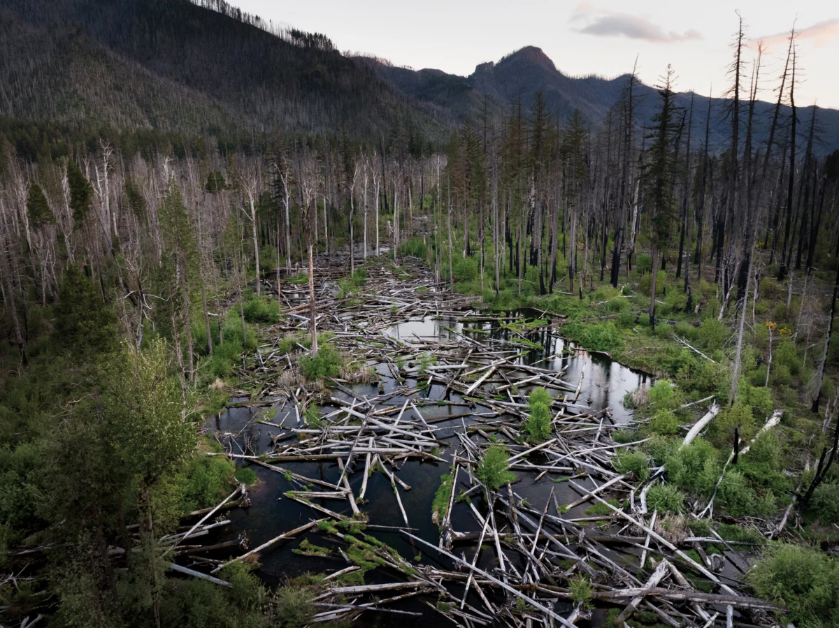
An hour’s drive east of Eugene, Oregon, Quartz Creek tumbles down the flanks of the Western Cascades, widening into a valley before merging with the McKenzie River. This area, a testament to the dynamic interplay of geology and ecology, is now the site of an ambitious, large-scale river restoration project employing a novel approach known as Stage 0. The project seeks to reverse decades of human alteration, aiming to re-establish a complex, wetland-rich riverine system.
The natural history of Quartz Creek and its valley is a story of constant flux. Approximately 12 million years ago, tectonic uplift formed the rough shape of the Western Cascades from a volcanic plateau. Over eons, the relentless forces of rain and ice sculpted this nascent mountain range, carving deep canyons and carrying eroded sediment downstream to form broad, gentler valleys. In these depositional zones, water naturally spread across the land, creating intricate wetlands laced with a multitude of branching channels. This dynamic environment was once a vital nursery for species like Chinook salmon, bull trout, and Pacific lamprey, which hatched and matured in the slow-moving waters before some embarked on migrations to the Pacific Ocean. Their eventual return, laden with marine nutrients, nourished the surrounding riparian forests of cottonwood, fir, and hemlock. The ecosystem was further shaped by natural disturbances such as windstorms, wildfires, and landslides, which toppled trees, adding vital wood to the system. Beavers, acting as natural engineers, would then dam this wood, creating ponds and further altering water flow, fostering a mosaic of deep pools, turbulent confluences, sandy bars, gravel beds, and slow side-channels. This constant, yet balanced, environmental dynamism sustained a rich diversity of life, which in turn supported indigenous peoples like the Kalapuya, Mollala, and Warm Springs, who utilized the area for fishing, hunting, and gathering.
The arrival of Euro-American settlers in the mid-1800s marked a profound shift. By 1860, the U.S. government had forcibly relocated indigenous tribes to reservations, and settlers began intensive logging. Streams like Quartz Creek, with their seemingly unruly floodplains and unpredictable flows, presented obstacles to development. In response, newcomers engineered the landscape by digging drainage ditches, constructing berms, and elevating roadbeds. This intervention began to consolidate the creek’s many threads into a more confined channel. The concentrated flow deepened the stream’s bed, while the surrounding floodplain grew progressively drier. With fewer downed trees reaching the water and accelerated currents flushing sediment, the calm pockets essential for fish habitat diminished. Consequently, Pacific lamprey populations declined, and Chinook salmon and bull trout vanished entirely from the system.

The effort required to transform Quartz Creek from a naturally complex wetland into a more manageable channel was substantial. Today, a new group of humans is engaged in a similarly labor-intensive endeavor, albeit with the goal of reversing the previous alterations. Armed with modern technologies such as excavators, LiDAR, and GPS mapping, they are working to re-establish the valley’s natural hydrological complexity.
This project is the latest phase of a broader river restoration initiative in the McKenzie River watershed, which began a decade ago. It employs the Stage 0 approach, a methodology designed to transform canal-like channels back into dynamic wetland-stream complexes by re-grading the valley floor. This process involves significant disruption of the existing landscape, and its long-term effects are still under study. Geomorphologist Gordon Grant has characterized it as "a full-on field experiment," and its unprecedented scale has generated debate among those who value the McKenzie River for its recreational and ecological significance. While some express discomfort with employing such an intensive technique, others see it as a critical opportunity to repair historical damage before it is too late.
The McKenzie River historically supported a significant population of Upper Willamette River Chinook salmon, a species vital to the ecological health and cultural heritage of the Columbia River Basin. Once numbering around 110,000, this population now represents less than 2% of its historic abundance, yet it remains the largest remaining wild population, holding crucial importance for the species’ potential recovery. Projections suggest that without intervention, this population could face extinction by 2050. Elizabeth Goward, community engagement manager for the McKenzie River Trust, emphasizes the urgency: "We know we don’t know everything. But if we don’t act now, we could lose this species."
The intellectual roots of the Stage 0 approach can be traced back to fluvial geomorphologists like Brian Cluer, who, from his early experiences flying over landscapes, began to question the prevailing scientific understanding of river systems. Cluer observed that many remote river valleys lacked defined channels and resembled vast wetlands, a stark contrast to the idealized, single-thread meandering rivers often depicted in scientific literature, an archetype influenced by early studies of mid-Atlantic streams. These studies, however, were later found to have been shaped by the historical presence of mill dams constructed by Euro-American settlers, suggesting that the single-channel model was not a purely natural state but an artifact of human manipulation.

This realization, coupled with research in the Western U.S. and elsewhere that utilized advanced technologies like LiDAR to reconstruct landscape histories, began to shift scientific consensus. These investigations revealed that many precolonial streams likely exhibited a more complex, multi-threaded wetland structure. Cluer, along with fellow geomorphologist Colin Thorne, synthesized this growing body of evidence and their own observations to develop a new model of stream evolution, beginning not with a single channel but with a wet valley floor interlaced with numerous streams – a state they termed "Stage 0."
Concurrently, in the McKenzie watershed, fish biologist Kate Meyer and her team were grappling with the challenges of habitat restoration. Tasked with improving fish habitat in tributaries like Deer Creek, they encountered streams that had been channelized and stripped of vital wood debris through misguided "stream cleaning" efforts. These straightened, high-velocity channels, described by Meyer as "essentially a firehose," proved resistant to traditional restoration methods. While adding wood was standard practice, high-energy flows often washed it away, and sediment accumulation was slow.
Meyer’s team found inspiration in a different approach being tested in eastern Oregon. Biologist Paul Powers had observed that a landslide at a restoration site in the Siuslaw National Forest inadvertently created a more diverse habitat by dispersing the stream across the valley floor, increasing wetlands and slow-flow areas. He began experimenting with replicating this outcome at Whychus Creek by intentionally directing flows out of the channel and into the floodplain.
A pivotal moment came for Meyer in 2014 when Cluer and Thorne presented their Stage 0 theory. "It was a total epiphany moment," she recalled, seeing their practical experiences validated by theoretical research. When Powers joined the Deer Creek team in 2016, they decided to implement the Stage 0 approach there. The initial steps involved dismantling levees and using the material to fill sections of the channel. The results were immediate: the stream naturally spread across the floodplain, creating multiple slow-moving channels and deeper pools. The success of this initial work, which saw Chinook salmon spawning in Deer Creek for the first time since 1993, emboldened Meyer and her colleagues. By 2018, they embarked on a much larger Stage 0 project on the South Fork of the McKenzie, aiming to restore a 200-acre stretch.

The Stage 0 methodology, as it has evolved, involves several key steps. The first, and often most debated, is site selection, which requires identifying low-gradient, historically depositional valleys where streams can spread without impacting infrastructure. Practitioners then use historical clues and LiDAR data to map the valley floor’s original shape and create a grading plan. Fish are relocated, and the river is temporarily diverted. Heavy machinery is used to fill existing channels and remove levees, reshaping the valley floor. Large woody debris is strategically placed across the floodplain to create habitat and slow water flow. Finally, the diversion is removed, allowing the stream to disperse and begin the process of rebuilding the riverscape.
During a visit to Quartz Creek in August, the landscape presented a stark, almost devastated appearance. The machinery had completed its work, leaving behind a muddy stream flanked by acres of dusty soil strewn with felled trees. Thorne acknowledged the visual impact, noting that some observers liken it to "Ground Zero." However, Lara Colley, floodplain restoration projects manager for the McKenzie Watershed Council, viewed the scene with optimism. The staging grounds, once piled high with some 6,700 logs, were now largely empty, the wood distributed across the floodplain. Colley had meticulously sourced this material from timber thinning and wildfire recovery areas.
The Stage 0 effort in the McKenzie watershed has become a collaborative ecosystem of organizations. Since 2016, the Forest Service and the McKenzie Watershed Council have been joined by the Eugene Water and Electric Board (EWEB) and the McKenzie River Trust. This partnership, according to Goward, allows the work to continue despite challenges like federal budget cuts, bringing diverse perspectives and resources to bear. For EWEB, which provides drinking water to 200,000 people from the McKenzie River, stream restoration is intrinsically linked to protecting water quality. Susan Fricke, EWEB’s Water Resources Supervisor, explained that Quartz Creek’s sediment load during high flows has historically taxed their filtration systems. By spreading the flow across the floodplain, sediment will settle out before reaching the mainstem, reducing treatment costs and chemical use. "We consider the river part of our infrastructure," Fricke stated, emphasizing the proactive benefits of preventing problems.
The Confederated Tribes of Warm Springs have also contributed valuable input. Tribal fisheries biologist Logan Bodiford highlighted that Stage 0’s holistic approach to restoring river wetland corridors aligns with the Tribes’ goals for sustainable fisheries and the exercise of treaty rights to culturally significant resources. The Quartz Creek project’s design was led by Kate Meyer, who co-founded a restoration consulting company after leaving the Forest Service. Franklin-Clarkson Timber Co. provided access to its land through a 50-year stewardship easement. The National Oceanic and Atmospheric Administration funded the majority of the $9.5 million project with a substantial grant, made possible by the Infrastructure Investment and Jobs Act. The heavy construction work was carried out by Haley Construction, a family-run company with a long history in the region, adapting its logging expertise to river restoration.

The construction phase, which must be completed within a limited dry season, is a complex logistical undertaking. Randy Haley, co-owner of Haley Construction, described the process as "directing an orchestra," emphasizing the need for seamless coordination among the crew, the heavy equipment, the vast quantities of wood, and the flowing river. His daughter, Ashley Haley, project manager, echoed the rewarding nature of the work, which benefits both wildlife and the community. The dedication of the crew is evident, with some long-time employees returning seasonally to participate in these projects. Haley Construction’s evolution from a timber-focused company to one heavily involved in river restoration reflects shifting societal priorities and the need for adaptation.
The company now leverages its logging expertise to help repair some of the environmental impacts of the timber industry. "The knowledge of how to work with wood, in forests and around waterways, all that now lends itself to floodplain restoration," Ashley explained. Randy added that while acknowledging the past, "we can’t condemn the loggers. They were doing a job they believed was right, at the time."
Observing the heavy machinery reshaping the valley floor, a stark contrast to its former riparian state, and with the surrounding mountainsides scarred by the 2020 Holiday Farm Fire, the impact of restoration can be visually jarring. However, the fire itself played a significant role in advancing Stage 0 work. It provided an abundance of readily available logs and made the use of heavy equipment more palatable, as entering a scorched valley is less disruptive than a pristine forest. More critically, preliminary observations suggest that the 200-acre Stage 0 restoration site on the South Fork of the McKenzie acted as a natural firebreak during the blaze. While unrestored areas experienced uniform, severe burning, the restored region burned in patches, allowing wildlife to find refuge and facilitating quicker forest recovery. This unexpected benefit highlighted the project’s potential for enhancing fire resilience.
In the weeks following the Holiday Farm Fire, the devastation was palpable for local residents. However, as one revisits areas like Quartz Creek, the potential for renewal becomes evident. The disheveled appearance of the construction site has given way to clear water flowing through braided streams, parting around logjams and depositing sand. This scene, with its inherent unpredictability, offers a sense of possibility.

The Stage 0 approach, sometimes referred to as a "valley reset," offers a compelling narrative of starting anew. However, advocates and critics alike caution against viewing it as a simple return to a pristine past. Thorne emphasizes that the goal is not to recreate a pre-Columbian landscape but to "empower nature" to continuously shape and reshape the riverscape. This, they believe, will foster greater habitat diversity and ecological resilience in the face of climate change. "Will it come out like it did before? Probably not," Thorne conceded. "It’s a different world now, a different river, a different catchment."
Critics, including David Rosgen, a proponent of the Natural Channel Design method, argue that the extensive wetland-stream networks characteristic of Stage 0’s initial state may not have existed in all landscapes, particularly in steeper valleys. Rosgen believes Stage 0 can be effective in very low-gradient areas but cautions that applying it universally can be detrimental. He suggests that rivers like Quartz Creek and the South Fork of the McKenzie would be more stable and ecologically beneficial as meandering channels.
Gordon Grant, a retired research hydrologist with extensive experience studying Western Cascades streams, acknowledges the enthusiasm surrounding Stage 0, drawing parallels to the widespread adoption of previous restoration techniques. He views the landscapes being created on the McKenzie as "novel geosystems," distinct from anything in the area’s historical record. While supportive of experimentation as a means of learning and improvement, Grant stresses the need for rigorous study before widespread implementation. He points to past restoration failures as cautionary tales, urging careful consideration of potential risks.
Grant’s primary concern revolves around the large wood incorporated into Stage 0 projects. He worries about the potential for mobilized logs during severe floods to damage infrastructure and endanger public safety. While Stage 0 designs include logjams intended to trap wood, these systems are not foolproof, especially in high-energy mountain environments. "The potential for mischief has not been fully reckoned with," Grant warned. He likens the power of floodwaters to moving enormous logs as if they were toys, emphasizing that extreme flood events are far more destructive than typical flows. The risk associated with a "100-year flood," he noted, is significant.

The decision of which risks are acceptable, Grant observes, depends on who is involved in the discussions. In the context of Stage 0 projects, he notes, the primary focus is on improving conditions for fish, but a broader range of stakeholders and potential impacts must be considered.
Despite these uncertainties, research into Stage 0’s effects on fish populations is ongoing. While the assumption that "if you build it, they will come" is a driving force, studies of 17 Stage 0 sites have shown increases in low-velocity rearing habitat, expanded valley floor wetted areas, and greater production of macroinvertebrates, crucial food sources for salmonids. These changes may also benefit Pacific lamprey, a culturally significant species whose populations have declined dramatically.
However, the research also reveals challenges. Water temperatures in restored areas have tended to rise, and sediment composition has shifted from coarse to fine, which, while beneficial for lamprey, can pose risks to salmon. eDNA analysis has indicated an increase in overall aquatic biodiversity, including invasive species. "When you open up a channel, you open it up to everybody," noted researcher Brooke Penaluna.
The long-term success of Stage 0 projects remains a key question. While construction is rapid, the true restoration unfolds over years. Studies on Upper Willamette River Chinook populations following the South Fork Stage 0 project showed an initial surge in spawning beds, followed by a decline, possibly due to upstream dam operations that prevent natural scour flows necessary for sediment and vegetation dynamics. Researchers emphasize the need for creative solutions, including adaptive dam management alongside restoration efforts.

In late January, a visit to Quartz Creek revealed a landscape transformed. The dusty wasteland of the previous summer had been replaced by clear water flowing through braided streams, parting around newly established logjams. This scene, while still bearing the marks of heavy intervention, represented a significant step towards a more dynamic and resilient riverine system.
The inherent unpredictability of these restored systems, as noted by Grant, is both a warning and a promise. It signifies the limitations of current modeling capabilities but also the potential for unforeseen positive interactions among natural processes and species. Stage 0 projects require human participation alongside a multitude of other actors – trees, rain, rocks, fish, beavers, and insects – to shape the future river. This intertwining of vulnerability and hope defines the endeavor.
The surrounding landscape, still bearing the scars of the Holiday Farm Fire and facing the looming threat of future wildfires due to low snowpack, underscores the urgency of adapting to changing environmental conditions. As Goward observed, "Everything around us is changing. What we’re trying to do is restore the river’s ability to change with it." The clinking of pebbles in the stream, pulverized fragments of the ancient volcanic plateau, serves as a reminder of the ongoing geological and ecological processes at play, and the emergence of new grass through heaps of slash signals the persistent, restorative power of nature.