
 Joko Susilo
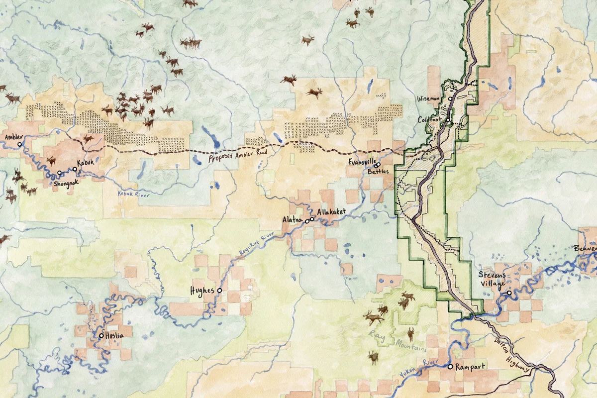
The Dalton Highway, a rugged 414-mile artery of gravel and ice, serves as the singular lifeline connecting Alaska’s established road network to its remote Arctic Coast, an indispensable conduit paralleling the iconic Trans-Alaska Oil Pipeline and facilitating the movement of vital supplies and personnel to the sprawling oilfields at its northern terminus in Prudhoe Bay. Flanking this industrial corridor, the immense Alaskan wilderness stretches largely undisturbed for hundreds of miles to the east and west, a breathtaking panorama of black spruce forests transitioning into formidable mountain ranges and vast, undulating tundra. This expansive, ecologically intact habitat is a globally significant carbon sink, playing a crucial role in regulating atmospheric carbon, while simultaneously supporting some of North America’s most iconic wildlife populations, including immense caribou herds, abundant salmon runs, moose, and diverse bear species. For dozens of remote Indigenous communities—among them Koyukon, Iñupiat, and Gwich’in villages—this landscape is not merely a backdrop but the very foundation of their cultural identity, spiritual connection, and food security, as they have lived in an intricate, symbiotic relationship with these animals and relied upon them for sustenance for millennia. However, a recent and pivotal change in the ownership status of the Dalton Highway corridor now casts a long shadow over the delicate ecological balance and the traditional ways of life sustained by this surrounding pristine wilderness.
Prior to the ambitious construction of both the Dalton Highway and the Trans-Alaska Pipeline System in the mid-1970s, a period marked by intense national energy demand and the landmark Alaska Native Claims Settlement Act (ANCSA), the U.S. Interior Secretary took decisive action. Through Public Land Orders (PLOs) 5150 and 5180, vast tracts of federal land were specifically set aside for the pipeline and highway route. These orders were not merely administrative designations; they were designed to prevent any conflicting uses that could impede the critical construction effort and, crucially, to safeguard the corridor from transfer to either the nascent State of Alaska or the newly formed Alaska Native corporations. By retaining the land under federal stewardship, the corridor remained subject to a robust framework of federal laws and regulations. These included stringent protections for historic sites, provisions safeguarding the subsistence hunting and fishing rights of rural residents, and mandatory requirements for proposed projects to undergo comprehensive public environmental review processes and meaningful tribal consultation—mechanisms intended to ensure transparency, accountability, and the consideration of local and Indigenous perspectives.
In a move that sent shockwaves through environmental and Indigenous communities, the Trump administration, in February, rescinded both Public Land Orders, effectively stripping federal protections from approximately 2.1 million acres of Bureau of Land Management (BLM) property within the corridor north of the Yukon River. Seizing this opportunity, the State of Alaska, which still maintained outstanding land entitlements totaling 5 million acres under the Alaska Statehood Act of 1959, promptly claimed two-thirds of this newly available land. The implications of this transfer are profound and far-reaching. Once federal land transitions into state hands, the legal landscape dramatically shifts, fundamentally altering existing hunting and access rights. The layers of environmental and cultural oversight, often viewed as cumbersome by developers but essential by conservationists, are significantly reduced. Furthermore, challenging proposed projects in state court becomes a much riskier endeavor for advocacy groups and Indigenous communities, primarily due to Alaska’s "loser pays" rule for legal fees, a financial deterrent that can stifle legitimate environmental and cultural preservation efforts.

"This is an incredibly destabilizing moment for the region’s ecology and its inhabitants," remarked historian Philip Wight, co-author of a significant 2024 paper examining the historical development and future implications of the Dalton Highway corridor. While a lawsuit seeking to reinstate the protective orders faced partial dismissal, environmental groups and tribal consortia swiftly filed an appeal on August 11, demonstrating their unwavering resolve. Regardless of the judicial outcome, activists have pledged to continue their fight, recognizing the immense stakes involved. April Monroe, the Native lands manager for the Tanana Chiefs Conference—a powerful consortium representing 42 tribal nations and villages that vehemently opposed the rescission of the orders—underscored the existential nature of the struggle. "The first, last, and only defense against climate crisis is intact ecosystems," Monroe asserted, highlighting the global ramifications of local land management decisions. "The fate of the world rests on whether they can be protected."
The State of Alaska’s primary motivation behind acquiring these lands centers on expanding access to its vast, untapped mineral and energy resources. This strategic land transfer is integral to its ambitions for developing new transportation routes extending north, east, and west from the Dalton Highway, aiming to connect the existing highway to state-owned lands and rich mineral deposits. Notably, the transferred acreage includes critical sections that the controversial Ambler Road, a proposed private industrial highway, would need to traverse. This new 211-mile route, envisioned as a direct pathway through pristine wilderness, would unlock access to extensive mining claims spanning the southern Brooks Range, an area believed to hold significant reserves of copper, zinc, lead, and other critical minerals essential for modern technologies, but also an area of immense ecological and cultural value.
The potential environmental ramifications of such development are severe, particularly for the region’s iconic wildlife. Caribou, known for their sensitivity to habitat fragmentation, face a grave threat. The Western Arctic caribou herd, a vital subsistence resource, has already experienced a alarming 75% decline since 2003. Scientific studies suggest that the construction and operation of the Ambler Road could critically disrupt or delay the herd’s traditional fall migration, a phenomenon already creeping later in the season due to the effects of climate change. Beyond terrestrial impacts, the proposed road would cross thousands of waterways, threatening the delicate ecosystems of struggling salmon runs, sheefish, and whitefish, species critical to both the regional biodiversity and Indigenous diets. Furthermore, extensive mining activities facilitated by the road would exacerbate these threats, introducing sediment and potential contaminants into sensitive aquatic environments.
The development also poses a significant risk to permafrost, the perpetually frozen ground that underlies much of the Arctic. The Ambler Road and its associated infrastructure would directly traverse permafrost-rich areas, inevitably accelerating its thaw. This process not only releases sediment and naturally occurring minerals, including heavy metals harmful to fish, into waterways but also triggers widespread land subsidence, destabilizing the landscape. Crucially, thawing permafrost releases vast stores of ancient carbon in the form of potent greenhouse gases, primarily methane and carbon dioxide, into the atmosphere, contributing significantly to global climate change and creating a dangerous feedback loop that further accelerates Arctic warming. The Arctic is warming at a rate two to three times faster than the global average, making the preservation of its frozen carbon stores a global imperative.

Beyond mining, consolidating the corridor’s ownership in state hands could also simplify the complex permitting and logistical challenges associated with another colossal energy project: a proposed 800-mile natural gas pipeline. This ambitious pipeline would parallel the Dalton Highway, connecting the enormous natural gas deposits of the North Slope to a proposed export terminal on the Kenai Peninsula. While the estimated price tag of up to $70 billion remains a formidable obstacle, any reduction in regulatory hurdles or land access complexities over time can significantly improve the prospects of such a megaproject. If built, this pipeline would inevitably spur increased Arctic drilling and associated development, potentially encroaching upon the embattled calving grounds of the Porcupine caribou herd, an internationally recognized herd whose migration routes span Alaska and Canada, and a critical resource for Gwich’in communities on both sides of the border.
The profound changes in land ownership and access rights directly threaten the food security of rural residents, both Alaska Native and non-Native, in a region where subsistence harvesting provides a substantial portion of their protein and cultural identity. Habitat fragmentation, resulting from industrial development, directly hinders wildlife movement and access to traditional hunting and fishing grounds. More immediately, the transfer of land out of federal jurisdiction often means that rural residents lose their priority hunting and fishing rights, which are often protected under federal law to ensure traditional uses. For example, in the community of Wiseman, local hunters who once were permitted to harvest one moose each winter on nearby federal lands must now either undertake arduous journeys to remaining federal territories or compete for limited tags in a statewide lottery, a system open to all Alaskans, including commercial guides catering to affluent out-of-state clients. This shift fundamentally undermines the ability of local communities to sustain themselves and perpetuates a systemic disadvantage.
Until this recent ownership shift, local residents engaged in subsistence activities like hunting or collecting firewood were among the few allowed to operate snowmobiles within five miles of the Dalton Highway, provided they were on federal land. With the transfer of ownership to the state, this crucial exception is rescinded, further complicating traditional practices. In response to concerns over access, the State of Alaska has committed to allowing snowmobile travel on 10 historic routes to facilitate resident access to adjacent federal lands and is actively working on establishing additional motorized easements. However, a critical distinction remains: these new routes and easements will be open to all Alaskans, not just local subsistence users. This broadening of access, while seemingly equitable, will inevitably lead to increased pressure on the land and its wildlife, intensifying human-wildlife conflicts and further stressing already vulnerable ecosystems and the communities that depend on them. This complex interplay of land claims, resource development, Indigenous rights, and global climate imperatives positions Arctic Alaska at a critical crossroads, where decisions made today will reverberate for generations to come.