
 Rocky Gerung
Initiated in 1961, California’s State Water Project (SWP) stands as one of the most ambitious water infrastructure undertakings in United States history, a testament to mid-20th century engineering prowess and a bold vision for harnessing the state’s water resources. Spanning over 700 miles from the snow-fed Feather River watershed in Northern California to Lake Perris in the south, the project’s first water deliveries reached Southern California in 1972, marking a significant milestone in the state’s development. The California Department of Water Resources (DWR) maintains an extensive public archive of photographs documenting this monumental endeavor, capturing a period of immense optimism and confidence in the state’s ability to engineer solutions for the arid West’s persistent water challenges. These images, largely taken between 1962 and 1968, offer a compelling glimpse into a time when grand public works projects were viewed not just as functional necessities but as symbols of progress and human ingenuity, capable of fundamentally reshaping the landscape.

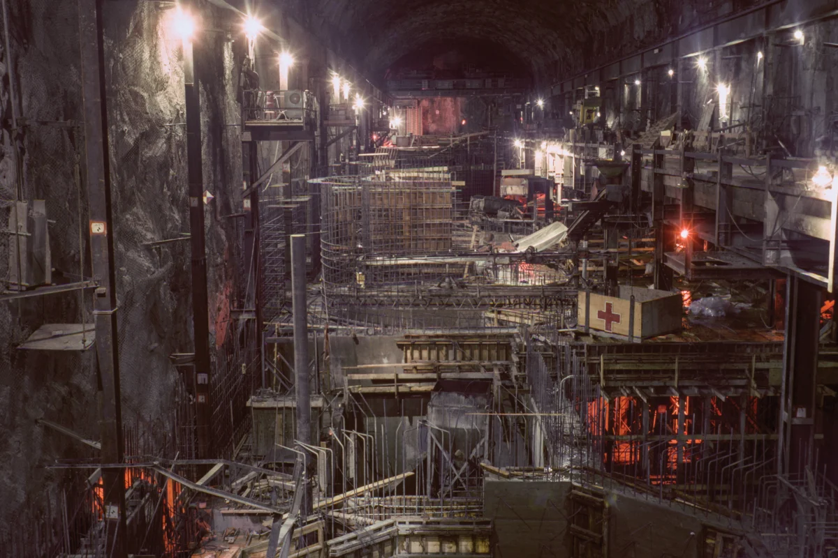
The construction of the Edward Hyatt Powerplant, situated near the Oroville Dam in Butte County, exemplifies the project’s scale and integrated design. Completed in 1967, this facility was engineered to maximize power production through a sophisticated pumped-storage operation. During off-peak electricity demand periods, water is pumped back into Lake Oroville, effectively storing energy. This stored water is then released for power generation during periods of high demand, serving both local and downstream needs while contributing to the overall energy grid. The visual narrative presented by the DWR’s archives, particularly the photos from the construction era, conveys a majestic and almost utopian vision of California. These images celebrate the state’s belief in its capacity to overcome natural limitations, embodying a powerful sentiment that large-scale infrastructure could definitively solve the region’s water scarcity.

The photographs showcase critical components of this vast network, such as the Dos Amigos Pumping Plant on the California Aqueduct-San Luis Canal in Merced County. Completed in 1966, this facility was instrumental in lifting water over 100 feet, enabling its continued journey south. The intricate assembly of rebar and concrete at sites like this underscores the immense labor and planning involved. Similarly, the construction of the Oroville Dam Diversion Tunnel No. 1, a 35-foot diameter conduit, highlights the methods used to manage water flow during the dam’s construction phase, which concluded in 1967. These tunnels, initially built to divert the Feather River, were later repurposed to discharge water from the Edward Hyatt Powerplant, demonstrating a long-term vision for resource management. Another vital element, the South Bay Aqueduct Surge Tank, also underwent meticulous construction, with workers applying primer coats to ensure its durability and functionality, as seen in photographs from May 1965.

These visual records are more than mere historical documentation; they express a profound sense of post-World War II optimism. They reflect a belief that humanity, through technological advancement and collective effort, could master nature and secure a prosperous future. The sheer scale of projects like the California Aqueduct served not only a utilitarian purpose but also a political one, projecting an image of a powerful and capable state, or even a nation, heroically confronting the challenges of aridity. As anthropologist Brian Larkin notes, the aesthetic dimension of such infrastructure often takes precedence, aiming to impress and inspire awe, thereby rearranging the perceived hierarchy of its functions. This mid-century perspective saw citizens readily rally behind such public works, a sentiment that appears less prevalent today, especially given the growing discourse around dam removal and the deconstruction of some water infrastructure.

The Sacramento-San Joaquin Delta, a vital confluence where the state’s two major river systems meet before flowing into the San Francisco Bay, serves as the nexus for both the federal Central Valley Project (CVP) and the southern reaches of the SWP. This intricate delta ecosystem, comprising over a thousand miles of levees, numerous reclaimed islands, and a complex network of waterways, has been the focal point of California’s water politics for decades. The images of the California Aqueduct vividly illustrate the transformation of this landscape into what Erwin Cooper, a former information officer for the DWR, aptly termed an "Aqueduct Empire." This empire, built on the principles of large-scale water management, visually dominates the state’s geography and, by extension, its political discourse.

The political vision underpinning the SWP and its operational infrastructure is palpable in these photographs, showcasing a landscape actively engineered to meet the demands of a growing population and economy. The project’s genesis coincided with the burgeoning environmental movement, marked by Rachel Carson’s seminal 1962 publication, Silent Spring. Over six decades later, the optimistic pragmatism of the 1960s has encountered the stark realities of the 21st century, characterized by escalating climate change and the cumulative impacts of extensive water resource development on the Western environment. The very infrastructure that once symbolized hope and progress now faces scrutiny as aging relics, often requiring significant maintenance and facing the threat of failure, as tragically demonstrated by the 2017 Oroville Dam spillway crisis that necessitated the evacuation of nearly 200,000 people.

The ongoing need for repairs and the potential for catastrophic failures highlight the challenges of maintaining such colossal systems. The B.F. Sisk Dam and San Luis Reservoir, a joint-use facility managed by the DWR and constructed by the Bureau of Reclamation, represents another significant component of this water network. Its completed inlet and outlet works, coupled with an extensive access bridge, underscore the intricate engineering involved in managing water storage and distribution. The Whiskeytown Dam, an earth-fill structure completed in 1963 by the U.S. Bureau of Reclamation, along with its distinctive "Glory Hole" overflow drain, also features prominently in the photographic record, symbolizing the state’s commitment to water control and management.

The dedication ceremonies for these massive projects often drew significant crowds, reinforcing their public significance. The Oroville Dam dedication in 1968, for instance, was attended by an estimated 3,500 people and featured prominent state officials, including Governor Ronald Reagan and DWR Director William R. Gianelli. The Oroville Dam, completed in 1967, was the tallest earth-filled dam in the United States at the time and served as the linchpin of the SWP, a testament to the state’s engineering capabilities and its commitment to water security. These events served not only to inaugurate critical infrastructure but also to foster a sense of shared accomplishment and civic pride.

The DWR’s Photography Unit continues its work today, with photographers documenting the state’s water infrastructure and management efforts. Bill Kelley III, the unit’s archivist, dedicates himself to scanning a vast collection of negatives and slides, a monumental task that ensures the preservation of this visual history. Kelley acknowledges that the initial purpose of these photographs was rooted in engineering research, but he also recognizes the DWR’s commitment to the long-term documentation of its water management activities. The sheer volume of photographic material generated over seven decades speaks to the enduring political power of imagery in justifying and promoting state water projects.

California’s population has surged dramatically, from 16 million in 1960 to approximately 39 million today, placing immense strain on its water resources. The fundamental imbalance between population distribution and water availability—with over 90% of Californians living south of Sacramento, while roughly 75% of the state’s precipitation falls in the northern regions—has been a persistent challenge. The narrative of California’s development, from the Gold Rush to the present era of acute climate change, is inextricably linked to its struggle for water security. The photographs of the State Water Project serve as more than historical records; they chronicle California’s enduring pursuit of a utopian ideal—a vision where abundant water perpetually nourishes its farms, cities, and industries, consistently defying the region’s inherent aridity and guaranteeing a promised future. However, the fundamental reality of the West’s arid climate, a geographic truth that has long defined the region, poses an ongoing challenge to this utopian vision, regardless of the scale of the infrastructure built or the compelling narratives captured in photographs. The pursuit of a water-rich utopia in an inherently dry land remains a complex and perhaps unattainable aspiration.